This title may sound like some kind of fantasy novel, but its premise is based upon sound archaeological evidence which actually makes most of our ‘official’ history sound exactly like some kind of fantasy novel. This article brings together many of the subjects we have been writing about over the last few years in a quite spectacular way. (Title image Eveengland, CC BY-SA 4.0)
● The ‘Dark Earth’ part… ○ The ‘Chronicles’ part… ○ Phantom Duplication ○ The Saint Pauls ○ Engima of the Religious Avatars ○ Mirroring ○ Pompeii ○ Connecting the dots… ○ Debunking the Cataclysm ○ One man's muck is another man's peat
● What Lies Beneath ‑ The Land ○ Bayesian Chronology ○ Peat Bog Surfing ○ Offerings to "Old Boggie" ○ Céide Fields, Ireland ○ Pete from the Bog ○ The Wittmoor Bog Trackways ○ Jórvík
● What Lies Beneath ‑ The Deserts ○ The Sahara ○ Timgad ○ The Taklamakan Desert ○ Leptis Magna
● What Lies Beneath ‑ The Oceans ○ The Septentrional Isles ○ Sunken Forests ○ The Hidden Depths of the North Sea ○ 1st Millennium Northern Europe Revealed ○ Hy Brazil ○ Lyonesse ○ The Storegga Slide & Tsunamis
● Strange goings‑on in the 1st Millennium ○ Archaeological Landmarks ○ Events Pre‑cataclysm ○ Events of the Cataclysm ○ Events Post‑cataclysm
● Aftermath ○ The Domesday Scenario ○ Doubting the Official Narrative ○ What on Earth…? ○ The Cause ○ No Point-of-Reference
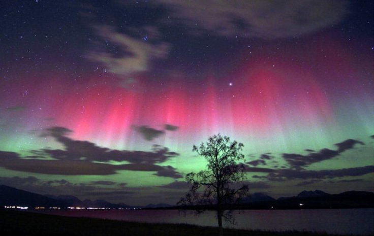
● Revising the 1st Millennium ○ Convenient Assumptions ○ King Arthur’s Lost Kingdom ○ The Northern Lights ○ Storm by Sorcery ○ Sensational Indoctrination ○ Hadrian’s Wall ○ “Friends, Romans, Huns and Farmers… "○ The Romans on the run ○ The Anglo‑Saxon Invasion Myth ○ Britain ‑ a Treasure Trove ○ 1066 and all that, again ○ 1066, a mirrored event?
● And finally…
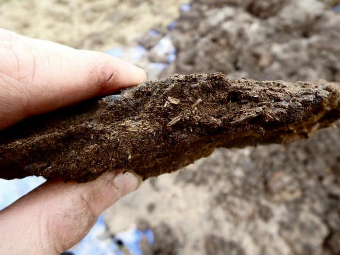
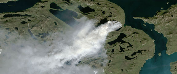
It all occurred quite by chance. My good friend ‘Silveryou’, a fellow reject of stolenhistory.net, sent me some of Gunnar Heinsohn’s research in which he spoke of a universal archaeological “dark earth layer” – quite literally earth or soil that is dark. It dawned on me that this dark earth might be identical to the archaeological ‘muck’ referred to in Felix’s ‘King Arthur in Hyperborea & the Arctic Cataclysm’ article. Further investigation revealed that this substance has many names; Black Earth, Peat, Chernozem (in Russia), Loam, Terra Preta as well as Muck and Dark Earth. There are probably more. Their commonality is that they are all composed of semi-decayed organic matter. Loam has a greater sand content than other forms and there are some conflicting and confusing claims regarding Terra Preta, which is found in the Amazon Basin of South America.
Felix’s article restricted the cataclysmic deluge of muck, dark earth or peat to the area comprising the Arctic Circle with a suggestion that it may have reached as far south as Scotland. He never directly mentioned a time period for the event as he was focusing purely on ‘archaeological muck’ and the remains of supposedly ‘prehistoric’ animals. He fell victim to the ‘divide and rule’ trick of isolating the Arctic event through the use of the term ‘muck’ combined with the same old ‘send it back into prehistory’ ploy.
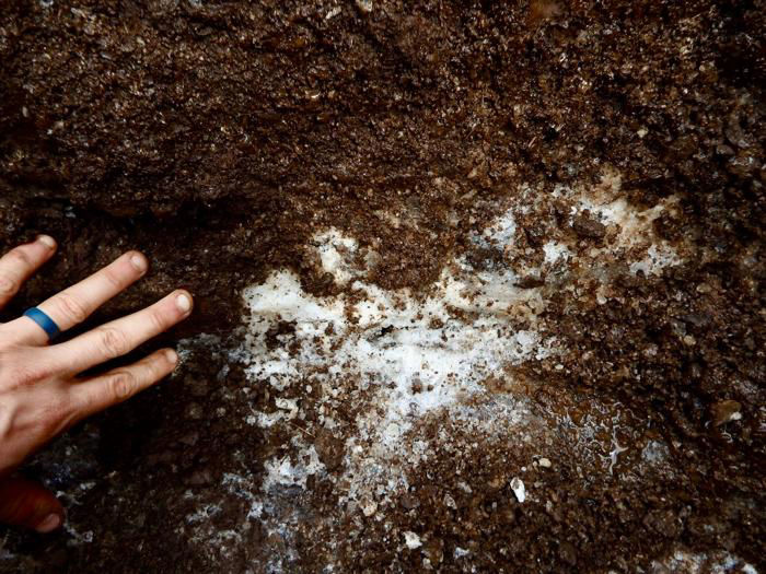
Arctic permafrost containing ‘muck'
Source
However, in his defence, he did speculate that the event took place after Arthur’s mission to the North Pole, which John Dee dated to 530 AD, and he also presented evidence from the 19th century that refers to the examination of a defrosted Siberian Mammoth by the Museum of the Royal College of Surgeons in London:
“The existence of the mammoth has been traced to a period so recent, that it no doubt approached nearly to, if it has not existed contemporaneously with, man. In what manner, and by what strange convulsion of nature, these animals were destroyed in the freezing latitudes of the Arctic circle, has never been explained, and will probably ever remain a mystery.” (Routledge's guide to the Crystal Palace and park at Sydenham - G. Routledge & Co. 1854.)
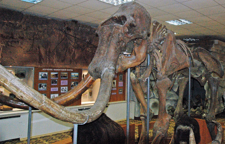
Woolly Mammoth at the University of
Alaska, Museum of the North
Enrico Blasutto, CC BY-SA 4.0
There is more to discuss regarding the Arctic cataclysm, evidence that wasn’t available to Felix at the time he wrote his article, but before we get into that I’d like to introduce the research of Gunnar Heinsohn because it blows the lid off the entire subject.
Gunnar Heinsohn’s research is also based upon the stratigraphic evidence of this same ‘muck’ or dark earth which has been encountered at archaeological sites outside of the Arctic Circle. His investigations have found this layer of dark earth at multiple sites across Europe as far south as Italy and Istanbul. This layer of dark earth is unmistakeable in the archaeological record. What is more important is that it dates to one specific time as, in general, there are never multiple stratigraphic layers of dark earth separated by normal ones. This one single contiguous layer of dark earth was deposited during one event and at one specific time – approximately 934 AD. It’s very important to keep that in mind as we delve further into the implications of this because it can get very confusing.
Heinsohn’s research goes on to show that the archaeological evidence pertaining to the 1st millennium does not match the official historical narrative - not by a long way. I don’t want to go into excessive detail regarding the evidence, because Heinsohn does it so much better than I do and his research is freely available on the internet.
The scenario that emerges from Heinsohn’s research is on the one hand quite simple, but on the other extremely complex. It’s clear that, at some time in the past, the chronology of the 1st millennium has been severely modified. Always keeping in mind there was but one cataclysm in 934 AD, it is obvious from the official narrative that this cataclysm has been displaced or sent back in time, not once, but twice, to earlier parts of the first millennium.
The first of these phantom echoes is generally described as The Crisis of the Third Century. The Crisis of the Sixth Century is the other phantom echo. So we have two approximate dates for these phantom cataclysms – 230 AD, which coincides with the supposed end of the western Roman Empire in the official narrative, and 536 AD – which coincides with the destruction of Constantinople in the official narrative. However, do not lose sight of the archaeological fact that these events never actually happened until 934 AD. There is no archaeological evidence whatsoever to support 3 individual cataclysms – in other words, evidence of the Third Century Crisis is never found below evidence of the Sixth Century Crisis. Likewise, evidence of the Third and Sixth Century Crises is never found under the Tenth Century Collapse, because it was just one 10th century event.
This artificial separation and duplication of one event that happened many years after the false phantom echoes has caused total chaos within our historical chronology. As a result, our official history has been filled with enigmas and conundrums which can only be resolved by reuniting written history with the archaeological facts. Much of Heinsohn’s research does exactly that as I’m sure you will see if you read his essays (which are not tediously long.)
So what really happened in the 1st millennium if everything we have been told is some kind of jumbled and dispersed record of events that took place in the 8th to 10th centuries? That’s a really good question, I wish I had the answer. Heinsohn does an excellent job of detective work on the reconciliation of archaeology with written history, but the task is monumental.
Not only was the actual 934 AD cataclysm event sent back in time and duplicated, but other events were also sent back in time and repeated during different periods. Unfortunately, it’s not possible to know just how many events could even be totally fictitious.
For example, St. Paul and his Paulinists are mentioned in the first century. Then we have Paulinus of Antioch with his Paulinians in the 4th century, followed by Paul of Samos In Antioch and his Paulicians in the 8th century. All of Heinsohn’s archaeological evidence points towards the 8th century Paul as being the 'original' source of the narrative, but does that actually mean it was genuine?

Saint Paul by Jean Morin, CC0, Public Domain
This presents another enigma. Jesus was claimed to have appeared to Paul 14 years after his death in 33 AD. Using the correct 8th century date for Paul also places Jesus in the 8th century, which is all a bit weird considering that the entire Anno Domini timeline is supposed to be based upon Jesus’ birth.
Muhammad is claimed to have been around in the 6th century and by the 7th century Islam was well established and fighting against the Roman Empire. However, Muhammad claims to have chatted with Jesus and other Jewish celebrities on his visionary trips to the heavens while he was in the cave being indoctrinated, therefore Jesus should have been born before Muhammad not the other way around. If we move Muhammad to the late 8th century as a possible ‘sent-back-in-time’ event, then Islam isn’t established until the late 800s and their conflict with the Roman Empire begins to overlap with the actual date of the cataclysm.
Then there’s the ridiculous mirroring of events, cultural features and people in the times of the 3rd century Severan Emperors and the 6th century Justinian period. Jewish wars and persecutions as well as plagues are also multiplied.
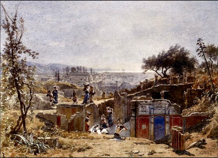
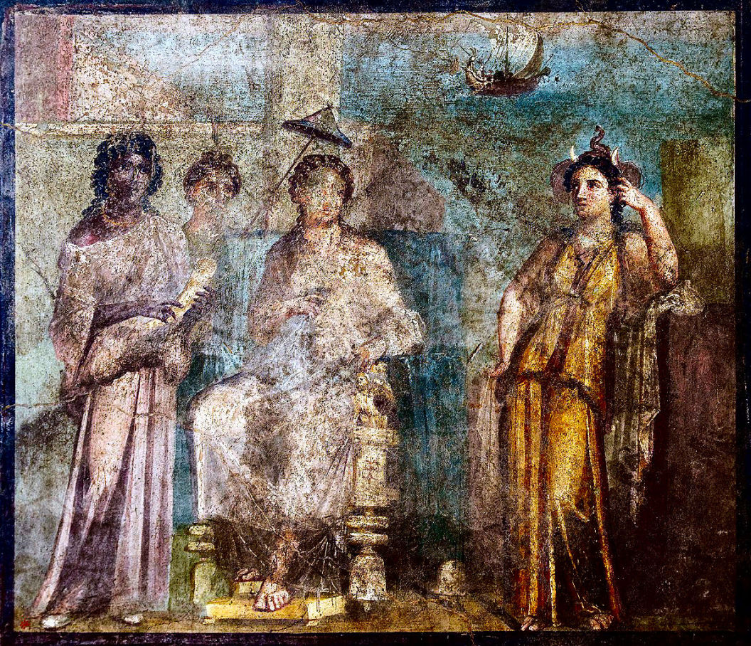
Excavations at Pompeii, c 1886
François-Louis Français, Public domain
One very telling event is the supposed 79 AD eruption of Vesuvius that destroyed Pompeii and Herculaneum. Andreas Tschurilow in his ‘Nicht der letzte Tag von Pompeji’ has shown that the true date for the destruction of Pompeii was actually 1631. This is interesting as it’s not possible to send an event back in time that hasn’t actually happened when you want to do the sending back. It means that this event was sent back in time after 1631.
Now if only we could connect the 10th century dark earth cataclysm with the Arctic Circle one… Felix?
Yes, well, let’s see. At the time I was researching the Arctic Circle event some years ago there was little information around, plus I was also fixated on the supposedly technical archaeological term ‘muck’ which I fell for hook, line and sinker and which served to isolate the event from any other 'dark earth' evidence. More recently I have become aware of various papers that have been written on the subject during the 19th century, but they are all locked up behind virtual bars that require money and the surrender of all your personal information to make them available.
Fortunately, I noticed that Graham Hancock, was also taking an interest in the subject and had summarised his research online, which included the sources that were unavailable to me.
His research resulted in a book entitled ‘America Before: The Key to Earth’s Lost Civilization’ published in 2019 and somewhat of a shock considering the research. It focuses on the end of the Ice Age and a period known as the Younger Dryas during which ‘a cataclysm’ supposedly took place some 12,800 years ago. Hopefully it will become obvious that the Younger Dryas event was actually the 10th century cataclysm which the mainstream narrative has sent back into a much more convenient place in the distant past.
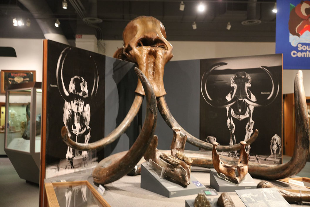
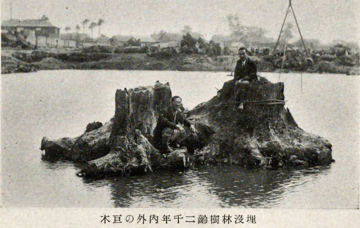
Anyway, early evidence for a cataclysm in Alaska began to appear in the late 1930’s and early 1940’s, but the evidence of extensive mammalian remains across the region dates back to 1813. Two scholars, namely Froelich Rainey and Frank C. Hibben both published on the issue during the 1930’s to 1940’s period. Renewed interest was inspired by the gold mining industry who were busy sluicing out “wide cuts, miles long and up to 140 feet deep” around the Tanana river in Fairbanks District, Alaska. In order to get to the gold it was necessary to remove vast quantities of frozen ‘muck’.
Arctic Muck
Source
“This ‘muck’ contains enormous numbers of frozen bones of extinct mammals such as the mammoth, mastodon, super-bison and horse, as well as brush, stumps, moss and fresh-water mollusks…. Because of the extinct mammal bones, the ‘muck’ is generally believed to be late Pleistocene or early post-glacial. No adequate explanation of the age of these deposits nor the manner in which they were formed can be given at present.” (Froelich Rainey, April 1940 issue of American Antiquity.)
At this point I must make it absolutely understood that the remains of these extinct mammals were not fossilised, but absolutely fresh. Many still had skin, hair and even undigested food in their digestive tracts. These days “A fossil (from Classical Latin fossilis, lit. 'obtained by digging') is any preserved remains, impression, or trace of any once-living thing from a past geological age,” according to Wikiperdida. When Will and I were at school fossilisation was a very specific process whereby organic matter became petrified by the very slow and very gradual replacement of its cells through mineralisation, whereby it literally turned to stone.
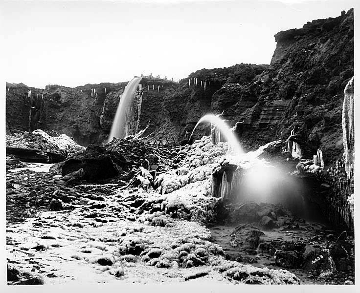
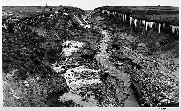
Hydraulic mining, Alaska, ca. 1904
Frank H. Nowell, Public domain
Today, referring to something as “a fossil” immediately assigns it to a past geological age whether it originated there or not. Please be aware, the mammalian remains found in the Arctic are not fossils, they have not been fossilised. The term ‘Fossil Ivory’ is an equally stupid one, because ivory that has been fossilised would be stone, not ivory.
Rainey also reported that 19 man-made artefacts were discovered in the muck, some of which were found “frozen in situ at great depths and in apparent association with Pleistocene fauna.” (ibid.) Both he and Frank C. Hibben, who published his findings in 1941, came to the conclusion that “men were contemporary with extinct mammals in Alaska.”
“Animals at present identified from the Alaska muck include the mammoth, mastodon (although not nearly so common as the mammoth), horse, at least three species of bison, (Bison crassicornis, Bison occidentalis, and Bison alleni), two species of musk ox, saber toothed tiger, lion, camel, gazelle, antelope, an extinct bear, sheep, and a number of rodent forms. In addition to the above now extinct species, there also occur moose and caribou, similar to, if not identical with, living forms.” (Frank Hibben, December 1941)
During 1941, Frank Hibben and a team of archaeologists undertook extensive field investigations in the Alaskan muck deposits…
“Although the formation of the deposits of muck is not clear, there is ample evidence that at least portions of this material were deposited under catastrophic conditions. Mammal remains are for the most part dismembered and disarticulated, even though some fragments yet retain, in this frozen state, portions of ligaments, skin, hair, and flesh. Twisted and torn trees are piled in splintered masses concentrated in what must be regarded as ephemeral canyons or arroyo cuts.” (Frank Hibben, January 1943 issue of American Antiquity.)

Mammoth Hair from Yakutia, northern Siberia
James St. John, CC BY 2.0 Public domain
Hibben’s 1946 book, ‘The Lost Americans’ went even further:
“These bones are found all over the central region of the northern Alaskan Peninsula embedded in the typical Alaskan ‘muck’… In many places the Alaskan muck blanket is packed with animal bones and debris in trainload lots. Bones of mammoth, mastodon, several kinds of bison, horses, wolves, bears and lions…
“Within this mass, frozen solid, lie the twisted parts of animals and trees intermingled with lenses of ice and layers of peat and mosses. It looks as though in the middle of some cataclysmic catastrophe of ten thousand years ago the whole Alaskan world of living animals and plants was suddenly frozen in mid-motion in a grim charade… Throughout the Yukon and its tributaries, the gnawing currents of the river had eaten into many a frozen bank of muck to reveal bones and tusks of these animals protruding at all levels. Whole gravel bars in the muddy river were formed of the jumbled fragments of animal remains…
“Within these oozing piles, the bones of mammoth, camel, horse, moose, and carnivores were everywhere in abundance…
“Mammals there were in abundance, dumped in all attitudes of death. Most of them were pulled apart by some unexplained prehistoric catastrophic disturbance”
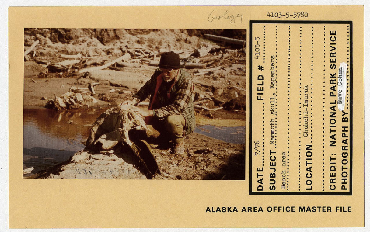
Mammoth skull, Espenbers Beach, Alaska, 1979
National Archives at Seattle, Public domain
Hibben’s insistence that the mammal remains and hence the cataclysm, were 10,000 years old is based upon nothing at all other than a knee-jerk reaction to the discovery of “prehistoric” Ice Age mammals. The often stated insistence that these specimens are found at all depths rules out the possibility that the muck took thousands of years to form, but was deposited and then almost immediately flash-frozen during one massive event.
As might be expected, a full scale assault against Frank Hibben began in 1955 and continues to this day. Of course, the Alaskan muck accumulated over a period of 2 - 3 million years. (What follows is quite detailed and exhaustive, but it does demonstrate, beyond any reasonable doubt, that there were the remains of mammals that were presumed extinct millions of years ago, discovered within the frozen muck throughout the Arctic and in vast quantities.)
The greatest antagonist, “geologist Paul Heinrich, tells us, with blunt certainty, that ‘papers and monographs published in the last fifty years have shown the claims and descriptions made by Rainey and Hibben concerning the abundance and distribution of fossil [FN: NOT FOSSILISED!] bones to be grossly exaggerated and quite inaccurate.
“Even more surprising than the non-mention of Hibben in papers that are claimed to debunk his work is the disturbing discovery that a number of the sources cited by Heinrich as disproving Hibben’s catastrophism in a number of ways do the exact opposite and in fact add several layers of further confirmation to his unorthodox conclusions…
“Amongst the papers that Heinrich cites as proof of the ‘exaggerated’ and ‘inaccurate’ nature of these claims is... Pewe’s authoritative study, Quaternary Geology of Alaska, published by the U.S. Geological Survey in 1975. But far from disproving Hibben and Rainey on the abundance and distribution of fossil bones, the Pewe study seems rather to confirm their findings. The best way to make this clear is to cite Pewe at length:
‘Alaska, like northern Siberia, has long been famous for the abundant remains of extinct Pleistocene mammals, found in frozen deposits along major rivers and in the valleys of many minor streams. The earliest account of these fossils seems to be that of Kotzebue (1821, who found abundant vertebrate remains at Elephant Point in Eschscholtz Bay during his expedition to the Chukchi Sea in 1816). F. W. Beechey also collected there, and the mammal bones were reported by Buckland (1831). Because early explorers (Dall, 1869, 1873) reported a great abundance of bones, several expeditions were conducted in Alaska in the hope of finding complete skeletons or perhaps even frozen carcasses comparable with those found in Siberia (Maddren, 1905; Gilmore, 1908; Quackenbush, 1909). When large-scale gold mining began in the Fairbanks district in 1928, extensive fossil collecting was undertaken there and elsewhere in Alaska by the late O. W. Geist and others on behalf of the American Museum of Natural History. A small part of this material has been described by Frick (1937) and Skinner and Kaisen (1947).
‘Later, Geist and others collected vertebrate fossils from the Fairbanks area and northern Alaska for the Museum of the University of Alaska. Some of the most detailed work ever done on the late Pleistocene mammals in central and western Alaska was that by Guthrie (1966; 1967; 1968; Guthrie and Matthews, 1971), who studied collections that he had made, as well as the vast collection of Geist.
‘The greatest collection of vertebrate specimens is from the Fairbanks area, where tens of thousands of specimens have been collected during the past 30 years. For example, in 1938, a typical year, 8,008 cataloged specimens weighing about 8 tons were collected by O. W. Geist and shipped to the American Museum of Natural History in New York City (University of Alaska, “Collegian,” 1938, fall). Partial lists of mammals from the Fairbanks area were given by Frick (1930, 1937), Wilkerson (1932, p. 422), Mertie (1937, p. 191), Stock (1942), Hibben (1943), Taber (1943, p. 1487), Skinner and Kaisen (1947), Skarland (1949, p. 132-133), Pewe (1952a, table 4), Geist (1953), Pewe and Hopkins (1967), and Guthrie (1968a).
‘The geological literature (U.S. Geological Survey Bulletins) in Alaska dealing with early placer mining activities mentions in passing that bones of extinct animals such as mammoth, mastodon, bison, horse, and others were found in many localities in addition to the Fairbanks area. Vertebrate remains on the Seward Peninsula were mentioned by Collier (1902), Quackenbush (1909), Hopkins (1963), Harington (1970a, b), and many others. Mertie (1937, p. 190-191) summarized finds of several specimens from the Yukon-Tanana Upland. Whitmore and Foster (1967) listed finds from Chicken and Lost Chicken Creek, including Panthera atrox, and Repenning, Hopkins, and Rubin (1964) listed fossils from Tofty.
‘Chapman and Sable (1960, p. 124) mentioned mammoth tusks found along banks of the Utukok and Kokolik Rivers of northern Alaska. Other references to vertebrates on the Arctic Coastal Plain were made by Livingstone, Bryan, and Leahy (1958), Harington (1969), and others. William Quaide (unpub. data, 1953) collected mammal remains along the Kuk and Ikpikpuk Rivers in northern Alaska, and Robert Fladeland identified wolf, bear, large cat, mammoth, horse, moose, caribou, musk ox, and bison. A Saiga [antelope] bone was also identified in this collection by C. R. Harington (C. E. Ray, oral commun., Feb. 12, 1970). C. A. Repenning (written commun. to D. M. Hopkins, Feb. 5, 1962) provisionally identified many vertebrate remains collected by W. J. Maher from the Ikpikpuk River including Smilodon sp. [sabre-toothed tiger] and Felis (Lynx) lynx. Ray (1971) reported that bones of the woolly mammoth were found on St. Lawrence, Pribilof, and Unalaska Islands on the Bering-Chukchi platform.
‘So on the one hand we have Heinrich pouring scorn on Hibben for his claim[s]... On the other hand, however, we have Pewe, one of the very sources that Heinrich offers as proof that Hibben’s claims and descriptions were ‘exaggerated’ and ‘inaccurate’. Yet, in the passages quoted above, Pewe offers no such proof. On the contrary, he cites Hibben himself and refers unambiguously to ‘the abundant remains of extinct Pleistocene mammals, found in frozen deposits along major rivers and in the valleys of many minor streams.’ Moreover, is not Pewe precisely describing ‘trainload lots’ of bones and remains when he informs us that:
‘The greatest collection of vertebrate specimens is from the Fairbanks area, where tens of thousands of specimens have been collected during the past 30 years. For example, in 1938, a typical year, 8,008 cataloged specimens weighing about 8 tons were collected by 0. W. Geist and shipped to the American Museum of Natural History in New York City.’ Source
I apologise for the excessive detail of the above quote and I hope you are still awake if you actually made the attempt to read it. However, as we will see, it’s very important to establish the abundance of mammalian remains as being a fact rather than the whim of just one or two… ‘nutters’. Also, let's not forget that this identical phenomena occurs in the Yukon territory of Canada and also in Siberia. The Siberian evidence was presented in my previous article, ‘King Arthur in Hyperborea and the Arctic Cataclysm’, along with evidence from drill core samples carried out in Alaska.
Please note: There have never been any dinosaurs found in the Arctic muck. There’s a shocker eh?
Woolly Mammoth, Tirekhtyakh River, Siberia, 1799
James St. John, CC BY 2.0
In 1978 Robert M Thorson, David C Plaskett and E James Dixon Jr. produced a paper entitled ‘A Reported Early-Man Site Adjacent to Southern Alaska’s Continental Shelf: A Geologic Solution to an Archeologic Enigma’, which appeared in Quaternary Research in 1978. Despite the ridiculously long title, it was actually yet another attempt to debunk the Hibben material.
In this paper, the authors claim that the deposits Hibben identified in Chinitna Bay, Alaska in 1943 were much more recent than he claimed. According to their radiocarbon dating, Hibben’s Chinitna Bay site is less than 1000 years old. This means it dates to around the year 978. Given the level of accuracy of radiocarbon dating techniques in 1978 (and today), it’s not unreasonable to postulate that the date of 934 may be equally feasible – the date of the 10th century cataclysm identified by Heinsohn. We are talking about a deviance of 44 years from an archaeologically verified cataclysmic event rather than the vague 9,000 or even 2 – 3 million years everyone else has assumed for the Arctic muck deposits.
Whilst this revelation served to discredit Hibben and his theories of an Ice Age cataclysm, it caused a big problem for Robert M Thorson & Co. How can the muck deposits contain mammoth remains if they are so recent? Well, they simply circumvented the issue by claiming that the bones Hibben identified were whale bones and / or of uncertain identity or provenance.
Hydraulic mining, Alaska, ca 1904
Frank H. Nowell Public domain
Hopefully, I have provided enough evidence to demonstrate that the entire Alaskan area is awash with mammoth remains and that Hibben had enough experience not to confuse mammoth remains with those of a whale. Obviously, this one example of radiocarbon dating of the Arctic muck to 1000 AD probably won’t be enough for some to consider as verification that the Arctic cataclysm happened at the same time as the 10th century event. However, the purpose of the 1978 archaeological dig was to discredit Hibben’s cataclysmic theory and safeguard the “prehistoric” scientific and geologic dogma of the official narrative. In this particular instance, using the standard tens-of-thousands or hundreds-of-thousands of years old radiocarbon dating would not serve their purpose. Using the correct radiocarbon dating did though, as it totally discredited Hibben’s theory and made it seem like a phenomena that was purely local to Chinitna Bay, plus it can never be disputed or disproved because it’s genuine.
So, there you have it Will, in my opinion, the Arctic Circle ‘muck’ cataclysm and the 934 AD ‘dark earth’ cataclysm were one and the same event.
“The age of the ice may be equal to or less than that of the cold climate under which it was formed. In the discussion of the age of the frozen ground we found a thousand years as a lower limit. The ice may be this old, at least. The relative ages of the ice and frozen ground will of course be different, according to the methods of formation of the ice. A body of ice that is buried and ·preserved may be nearly contemporaneous with the ground formation. Where the ice is formed in place, it will of course be younger. Such methods of formation by burial as are possible under modern conditions can not point to a very great age, nor can the doubtful method of formation in place advanced by Tyrrell...
“Belcher’s theory, as elaborated by Holmsen, is also very doubtful, and nothing is known of the rate of supposed upward growth of the ice. The theory of burial of great Pleistocene snow fields, as advanced by Toll and others, necessitates such changes in climate that the postulated great age should be questioned...
“If the theory of the origin of the wedge shaped masses of ice is true, as outlined above, we have a method of estimating the age of the ice with a fair degree of accuracy. The width of the wedge and the rate of growth are all that is necessary for this calculation. The width is readily ascertained, and a rough estimation from field evidence may be made of the rate of growth...
“In the area studied by the writer an age of 500 to 1,000 years is indicated."
Source: The Canning River Region, Northern Alaska, Ernest de Koven Leffingwell – 1919,
United States Geological Survey – Professional Paper 109.
This corroborates the radiocarbon dating of the 'muck' deposits of Chinitna Bay to an age of 1000 years cited above.
Thank you, Felix.
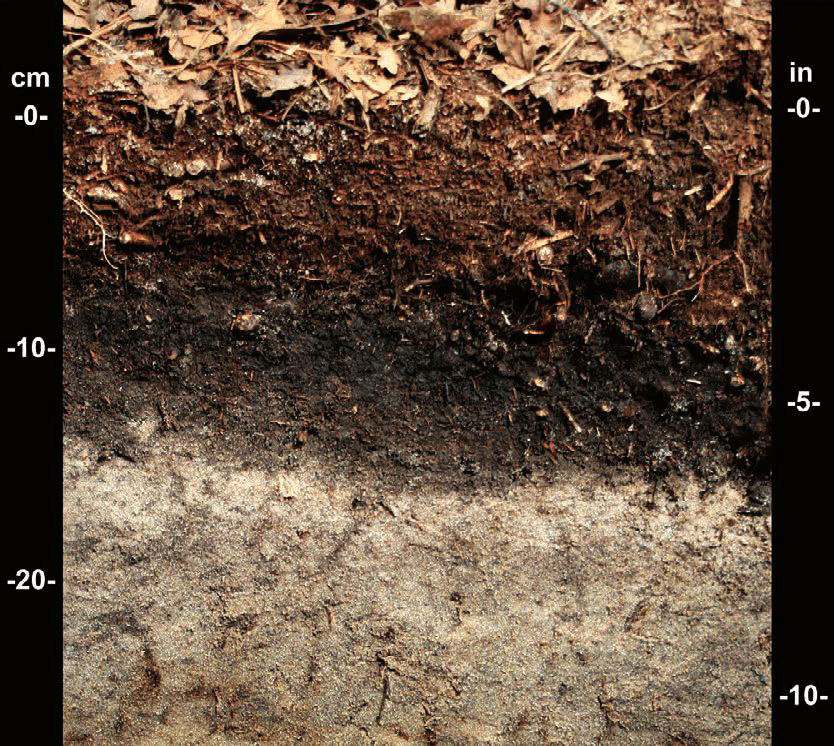
This can be further clarified by examining the composition of archaeological ‘muck’ and ‘peat’ or dark earth. The fact is that they are comprised of the exact same elements – semi-decayed organic matter, i.e. plant and animal remains plus moss. There may be variations across wide areas in regard to the amount of sand and moss incorporated, plus regional variations caused by local conditions, but these do not affect the basic composition. Actually, the cataclysm that deposited all of this material on a worldwide basis, could also have been responsible for the creation of Deserts, but more of that later.
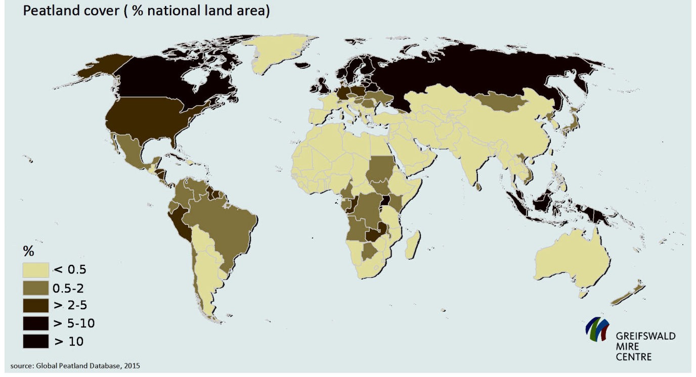
Greifswaldd Mire Centre
The above map is one of many similar images that can be found on the internet. It is inaccurate. Greenland is shown as being completely free of peat, whilst Alaska has only 2-5% of its total land area as peat, which is crazy as we have already seen that Alaska has much more peat than it could ever need. Also Greenland is totally 100% covered in peat. It is used annually as a Climate Change scare when the ice cover melts in the spring / summer and the underlying peat layer is set on fire… either spontaneously or otherwise.
Peat burning in Greenland 2017
Source
As well as being inaccurate, it should be noted that the map only shows the surface area of peat cover in relation to the total area – not the depth, which in some places amounts to hundreds of metres.
I think it’s clear, even with the inaccuracies of the map, that the epicentre or ‘ground-zero’ of the cataclysmic event that deposited all of this muck or peat was right at the North Pole.
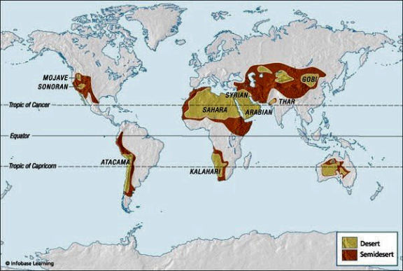
The World's Deserts
Source
It’s also highly significant that the location of the world’s deserts appears to follow on in a southerly direction from the peat cover. It’s as if the peat was mixed with more sand the further away from the North Pole it travelled until it became pure sand. More on this later.
Let’s see if what lies beneath the peat matches what lies there are in the official narrative. However, before we do, it’s necessary to clarify something very important with regard to the dating of all archaeological finds. I’m not going to cover the inherent inaccuracies of radiocarbon dating itself as that has already been done many times, but something even more insipid.
In the UK there is “a public body that champions and protects England's historic places,” or so it claims. It’s called Historic England. They have thousands of radiocarbon dating records that go back to the 1970’s from which they perform Chronological Modelling. This data is used at the time of all radiocarbon dating as part of the ‘The Bayesian Process’:
“The use of Bayesian statistics for the interpretation of radiocarbon dates reinforces the need for clear problem definition, the requirement for rigour in sample selection, and the need for explicit consideration of our pre-understandings in interpretation.” Source
If that doesn’t sound ominous enough then the definition of Bayesian Statistics states:
“Bayesian statistics is a theory in the field of statistics based on the Bayesian interpretation of probability where probability expresses a degree of belief in an event. The degree of belief may be based on prior knowledge about the event, such as the results of previous experiments, or on personal beliefs about the event.” Source
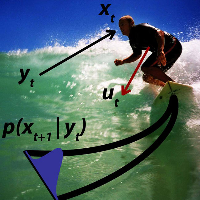
Bayesian Surfing
I. Stevenson & D. Flower CC BY 2.0
This technique is not unique to radiocarbon dating, but also to Genetic Testing and is used widely in medical research reporting. There’s even Quantum Bayesianism can you believe. The widespread adoption of Bayesian statistical models led to the publication in 2005, by John Ioannidis, of ‘Why Most Published Research Findings Are False’.
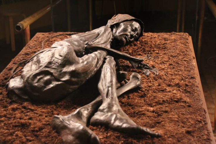
I can’t help wondering if at anytime amidst all of the remains that have been recovered from the excavations of muck in Alaska, there have been any human remains? They have found man-made objects, such as tools, but apparently no man-made people. Would they tell us if they did?
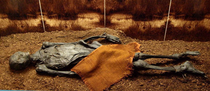
However, in other areas, such as Ireland, the UK and Scandinavia, bodies and many other things, are frequently retrieved from peat bogs. The official explanations for this phenomena are quite clearly defined and strictly limited. The unfortunate victims either fell in accidentally, were pushed in (i.e. murdered) or were ritually sacrificed.
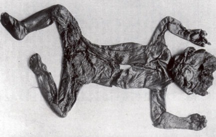
1928 Bog body ‘Röst Girl’, destroyed during WWII
Unknown author, Public domain
I don’t really understand why everything has to involve violence and or barbarism when it comes to these kind of explanations. Are we supposed to feel disgust at our own ancestors and guilt? Are we meant to feel so superior to such primitive people because now we kill with drugs and chemicals rather than face-to-face?
Less and less discoveries of bog bodies are taking place these days due to the mechanisation of peat digging which simply destroys anything it finds. Also, many peat bogs are now being given ‘protected’ status due to the usual over-exploitation by greedy corporations and the fact that everything natural now has to be protected against us unnatural human beings. It will also serve to prevent any more bodies or other things being discovered.
Tollundman, discovered in 1950
Museum of Silkeborg
“Scholars are also working to correct previous errors resulting from a tendency to sensationalize. Many injuries previously ascribed to torture or particularly violent means of execution were likely caused by more natural means. Grauballe Man's leg and skull were broken by the weight of the peat over millennia, not as part of his execution. And the fact that some bog bodies are naked can be attributed to the disintegration of their linen clothing after thousands of years in a wet, acidic environment, not some aspect of the ritual surrounding their death.” Source
Please note the “thousands of years” in the last quote. The torn and mangled remains of the mammals found in Alaska didn’t lead anyone to suppose that they had been violently murdered or sacrificed, but now we are dealing with human beings found under identical circumstances, suddenly these become the favourite options. Why is that?
Maybe there’s another equally valid explanation for these bodies and objects found beneath layers of peat. Maybe the peat dropped on them from a great height or swept them away in a peat avalanche?
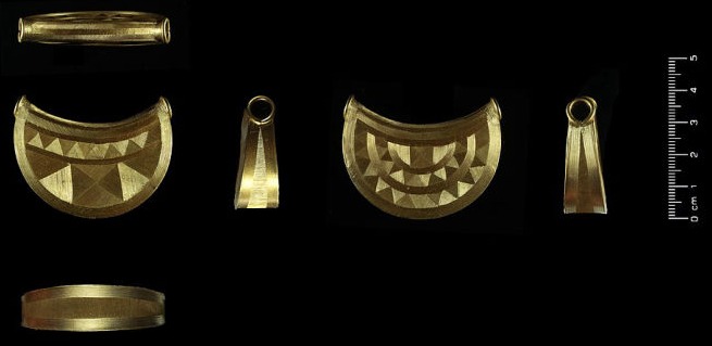
Gold ‘Bulla' from the Shropshire Marches (peatland) discovered 2018
Birmingham Museums Trust, CC BY 2.0
There’s also another popular theory that has grown out of all the sensationalism – that the ‘ancient Celts’ regarded peat bogs as sacred places or gateways to the Otherworld, hence all of the votive offerings they threw into the peat. Many so-called ‘hoards’ of highly valuable objects have been reported as coming from peat bogs, including weapons, jewellery, belts, buckles and torques. These are all considered to be votive offerings to… who? Well, who knows? As far as I’m aware there was no Celtic god of the bog. This always assumes that the valuable objects were placed in the bog rather than the bog landing on top of the valuable objects and covering them up. One might assume that valuable objects would be kept together in a secure, secret location – like a modern day safe – maybe for retrieval later like buried treasure. Such a location might easily be lost under a deluge of peat. But no, let’s just believe that these primitive people were so daft that they threw all their most precious possessions into the peat to appease ‘Old Boggie’.
I don’t deny that the ancient people would regard peat bogs as places of reverence – like a graveyard for example – especially if they were indeed mass-graves full of their ancestors who didn’t escape the cataclysm. However, to portray them as mindless idolators isn’t just insulting, it is a convenient explanation for the presence of assorted objects being found within the peat of which there are quite literally thousands ranging from the smallest glass beads to an entire village.
“Beneath a vast bog on Ireland's North Mayo Coast, a peat cutter in the 1930s stumbled across the 5,500-year-old remains of a complex of houses, megalithic tombs, and fields surrounded by stone walls that indicate a sophisticated Neolithic farming and grazing system. At around four square miles, it is one of the most extensive known Stone Age sites in the world.” Source
Now I ask you in all seriousness, how the **** does an entire village slowly become buried in peat over 5,500 years without anybody noticing?! Back in the 1930s did they just assume that the peat must have taken 5,500 years to cover the village and therefore it has to date from the Stone Age? I bet they did. Isn’t it logical, even sensible and reasonable, to conclude that the peat was dumped or even just materialised on the village in one fell swoop?
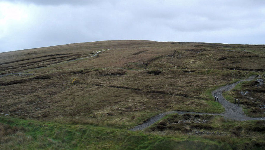
Céide Fields, County Mayo, Ireland
Public domain
The village’s 4 square mile site includes a cultivated field system that wasn’t to be seen anywhere else in the world for another 2,500 years and which remained in use up until the 10th century and became known as the Celtic System.
“The climate at the time was much warmer, leading to almost year-round growth potential. Samples taken from the remains of trees found in the bog provided evidence of this.
“For a while, these people prospered, but some changes led to the development of raised bogs and the transformation of the arable land into barren and unusable land.” Source
"Some changes," I wonder what could have caused that? Probably a bloody volcanic eruption or three. Maybe comet Fink-Knottle? How’s about the same 10th century cataclysm that left a layer of muck / dark earth / peat over most of the northern hemisphere? ...Nah.
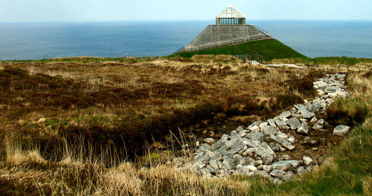
Ceide Fields with its freakish and highly inappropriate Visitors Centre
Source
Many years ago, Felix and I used to go on school trips to the museums in London – the Natural History Museum, Science Museum, etc. It was much more fun than working in a classroom and besides, it was considered an essential part of every child’s brainwashing. These days I suppose children visit the National Gender Definition Museum to see how the primitive folk used to define themselves as boy or girl, or man and women – imagine, no need to visit a psychiatrist to make that decision.
Anyway, we saw bog bodies in the museums and in fact, we were on first name terms with one of them whom we called Pete... Pete from the Bog. So, was Pete from the Bog murdered, did he fall in the bog by accident, was he drugged with a Mickey-Finn in his soup and then ritually slaughtered, was he hanged by the cord found conveniently around his neck or was he overwhelmed by a deluge of dark earth? You decide...
Rendswühren Man found in 1871 in the Heidmoor near Rendswühren, Germany
Dated around 1st or 2nd century AD.
Bullenwächter, CC BY-SA 3.0
“The overwhelming majority of bog bodies – including examples such as Tollund Man, Grauballe Man and Lindow Man – date to the Iron Age and have been found in northwest Europe, particularly Denmark, Germany, the Netherlands, the UK, Sweden, Poland, and Ireland.” Source
There’s even one that’s been dated to 8,000 BC. “Ha!” you may say, how does that fit with this cataclysm theory? Well, my answer would be that it doesn’t, but how can these bog bodies be older than the peat bogs they were found in? We have the exact same dilemma as with the mammoth remains in Alaska. Because the accepted ‘science’ states that it takes “thousands of years for peatlands to develop the deposits of 1.5 to 2.3 m [4.9 to 7.5 ft], which is the average depth of the boreal [northern] peatlands" Source
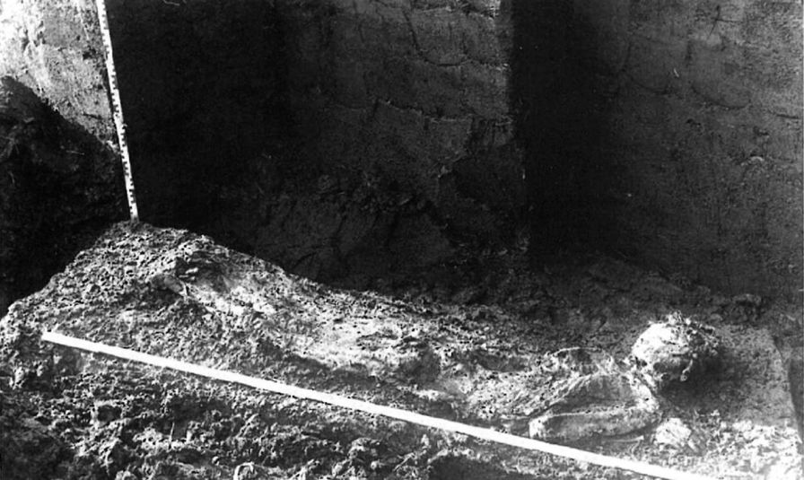
In situ photo of Nederfrederiksmose Man found on May 25th 1898 in the north west of Silkeborg, Denmark. The find dates to 1099 AD. (Note depth of Peat.)
This image is the first known photo of a bog body.
Georg Sarauw (1862–1928), Public domain
Their age is determined by the depth at which the body or object is found within the peat. This is the prime Bayesian criteria or element of personal belief, that maintains the official narrative. In instances of radiocarbon dating there appears to be an excess of specimens from the Iron Age rather than the 10th century. The opposite would be expected if the peat bogs were created by the 930AD cataclysm, so something somewhere is wrong. In fact, none of what are referred to as ‘notable bog bodies’ date to anywhere near the 10th century… which is very odd indeed. Also, as far as I’m aware, there are no instances of older or newer bodies (or objects) being found at different depths within the same peat bog, which is even more odd and which also means that there is no reliable point of reference for dating bodies or objects retrieved from peat bogs.
“Husbäke Man" in situ at the time of his excavation in 1936.
Unknown author, Public domain
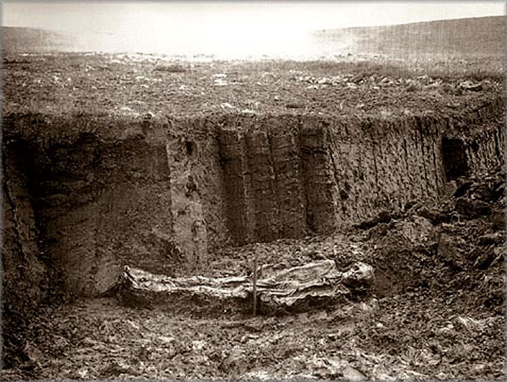
The north of Hamburg in Germany is an area prone to marshlands, somewhat like Holland, with a low-lying wet coastline. The Wittmoor bog is one such area and wooden trackways have been discovered that linked its eastern and western boundaries. Trackway number one was discovered in 1898 and number two in 1904. Number one was found 1 metre below the surface of the bog, buried in peat. The depth at which number two was discovered is not specified, but judging by the photograph below it was slightly less than the length of the oak thresholds, which are 1.6 metres.
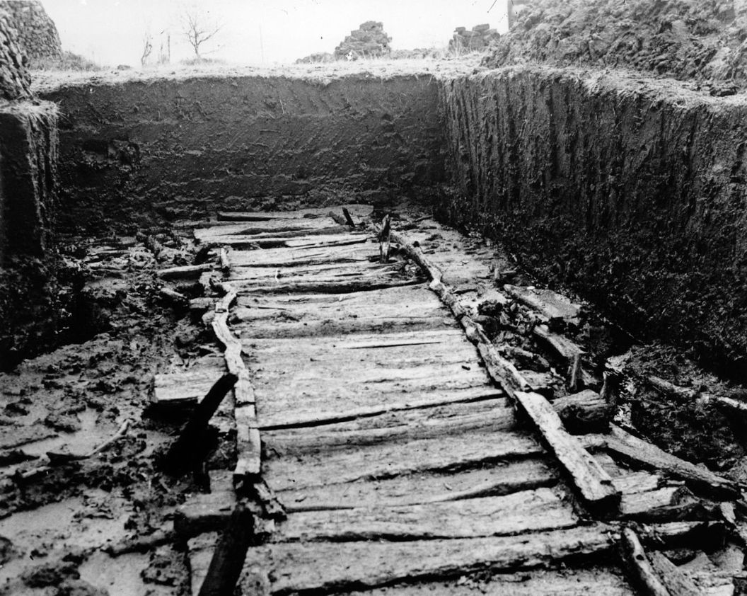
Wittemore Trackway Number Two
Archäologisches Museum Hamburg, CC BY-SA 3.0 DE
The obvious question is, “Why didn’t they build them on the surface of the bog?” Well they did. Apparently trackway number one was built in the 7th century, although no dating method is revealed and it is of a much simpler construction than trackway number two.
“In 1938 the bog trackway [number two] was initially dated by pollen analysis to the 6th century BC; however, a radiocarbon dating performed in 1957 yielded an age nearer the beginning of the Christian era. The most recent dendrochronological dating performed in 1996 yielded a felling date of the trees around the 330 AD.” Source
The construction of trackway number two is highly sophisticated with complex joinery, however, the experts says it’s older than number one… just because it’s deeper in the peat – I wonder? The thing is, there is NO explanation as to why these trackways are buried under the peat in the first place. They are claimed to have been highly important routes of communication and to have provided essential accessibility, but at some point they couldn’t be used any more. That would appear to have been a sudden occurrence, otherwise the trackways would have been kept clear of overgrowing peat by traffic and therefore now, there would be less peat over the trackways than on either side of them. However, the current surface above the trackways is completely flat and level (see photo above.) Could the peat have overgrown the trackways from either side and levelled itself off? Could it have grown up through them or was it dumped by a massive cataclysm in 934? You decide.
That’s supposedly the name of York as it was known to the Vikings. I don’t wish to get into a speculative discussion about the truth regarding the history of York, or Eboracum as the Roman called it. Given the situation with the cataclysm, it’s all up for grabs as far as I’m concerned. What’s of much more interest is the archaeological evidence from 10th century York… which they claim was called Jórvík at the time. This date is bang on the time of the 934 cataclysm.
“In this area of York there is up to 9m of archaeological layers which mostly date to the Viking Age. This great depth is highly unusual. [WS: They can’t even admit it’s just one big layer.]
“These layers are both moist and peaty and so preserve the organic remains of timber buildings, textiles from clothing and leather shoes; things which rot away to dust on most archaeological sites.
“The moist peaty layers also preserve seeds, insect remains, plants, animal bones, human parasite eggs and pollen; providing evidence that gives us information about past climate, diet, health, the countryside and other features of the ancient environment.” Source
Strangely, the Wikipedofile entry for the Centre claims that the artefacts were preserved in wet clay rather than peat… but I don’t think wet clay preserves stuff very well. The list of 40,000 artefacts recovered is impressive and can be viewed on the link above – the terms ‘Roman’ and ‘Viking’ are the only ones that feature… so, there were never ever any British people living in York then. There is a Disneylandish commercial flavour to the centre which was badly damaged by a flood in 2015.
The thing is, as far as I can tell and even more strangely, no one has asked the question – why was York covered in 9 metres of peat in the 10th century?
I’d like to briefly consider the possibility that the world’s deserts were created as a result of the same 10th century cataclysm that decimated the Arctic and caused the Dark Earth devastation in varying degrees across the world. This may be me trying to blame everything upon the Dark Earth Cataclysm, but it does have some logic to it and can be demonstrated as either valid or otherwise quite easily by examining the archaeological evidence.
“In ancient times, some thousand years ago, the Sahara desert was fertile grassland. Then something happened and the Green Sahara turned into a desert. Today there is enough evidence to show that the Sahara desert had once a grassland ecosystem and was a much wetter place than it is today." Source
Of course, the scientists, geologists and climate change modellers are all still arguing about how long the change to a desert has taken. Some say it began six thousand years ago while others say it happened ‘abruptly’, mind you their idea of abruptly is a 300 year period. Well, I agree with the abruptly brigade, but I say it happened one day in 934 AD.
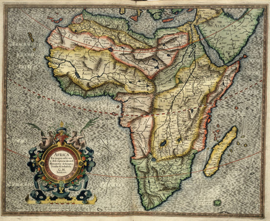
The Sahara Desert is 3,000,000 years old according to the official Bayesian Chronology. In 2018 Korben Dallas gave an excellent account of why the Sahara Desert is only 400 years old in the original stolenhistory.org website.
He reproduced maps from the 16th and 17th centuries that told a very different story about the Sahara area. As with most old maps, they were probably based upon earlier ones or incorporated visualisations of written descriptions from rediscovered earlier manuscripts or voyages of discovery and missionary expeditions. In fact, we will see some highly relevant evidence of that very process later. That these maps show the Sahara area as 'green' doesn't necessarily prove it was only covered in sand after the 17th century. As we shall see, there is other evidence to show that this would have been impossible. What these maps do show is that up until some reasonably recent time the Sahara area was not a desert.
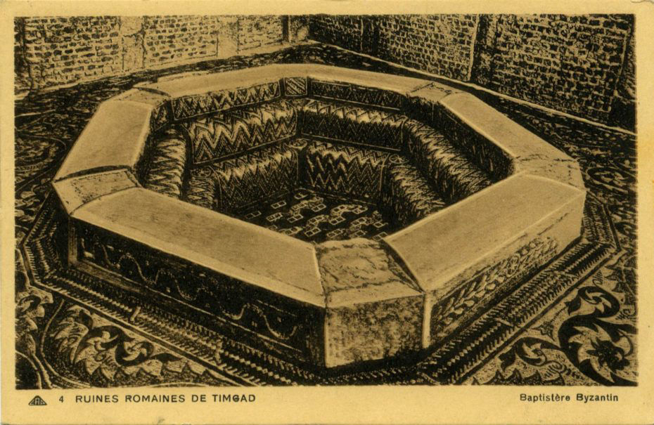
On the edge of the Sahara, in Algeria, there lies the "Roman" city of Timgad which was lost beneath the sands for one thousand years. It was apparently founded by the emperor Trajan in 100 AD and built as a retirement colony for soldiers. That must have been quite some retirement home being about 500,000 square metres in total with all manner of features including a library, a 12 m high triumphal arch made of sandstone, a 3,500-seat theatre, a basilica with a hexagonal immersion 'baptismal' font and some 14 bath houses. They also enjoyed a Capitoline Temple dedicated to Jupiter which “is of approximately the same dimensions as the Pantheon in Rome. Nearby the capitol is a square church, with a circular apse dating from the 7th century CE. One of the sanctuaries featured iconography of (Dea) Africa.” Dea is not a Christian saint, but a Roman goddess claimed to be the ‘personification of Africa’, also Christian churches tend not to be square and apses are always semi-circular, therefore referring to this structure as a ‘church’ is very misleading – ‘temple’ would be more appropriate.
Dido seated on a throne, attended by handmaidens, looking at Dea, the personification of Africa (right), wearing an elephant hide headdress. Aeneas' ship features in the background.
Public domain
Further investigation of the area by Sir Robert Playfair, British consul-general in Algeria, in the 19th century revealed that, “These hills are covered with countless numbers of the most interesting mega-lithic remains.” Source ‘Travels in the Footsteps of Bruce in Algeria and Tunis’ by Lieut.-Colonel B. l. Playfair, 1877.
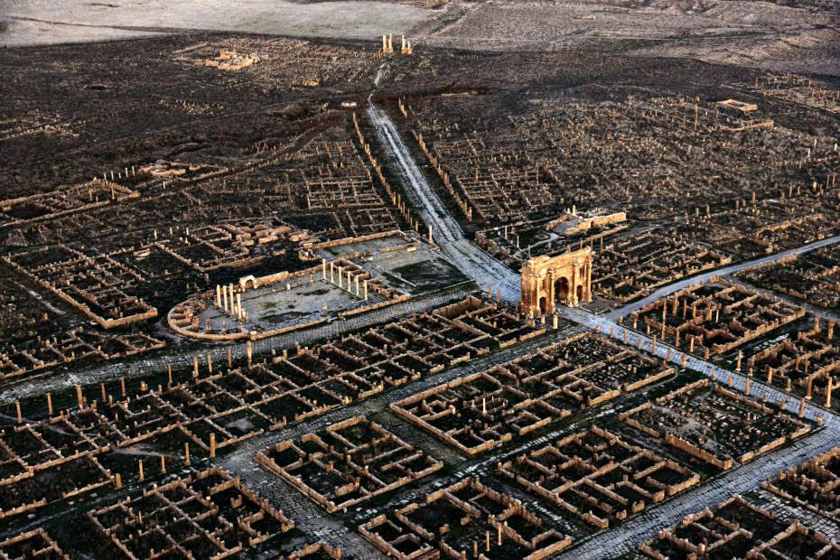
Timgad
Source
I know I said this was going to be brief, but as usual something comes up that demands attention and this is why we have loads of half-started, or half-finished articles, but zero new completed ones. Anyway, the claim that this retirement colony was built by Trajan in 100 AD doesn’t quite ring true. At that time the Romans were supposedly busy in Northern Europe with the Germanic tribes. However, if we fast forward to 398 AD we find that the Romans had a great deal going on in north Africa with the Gildonic War, a rebellion led by Comes Gildo against the Roman emperor Honorius. The revolt was subdued by Stilicho, the magister militum of the Western Roman empire...
“Stilicho sent the brother of Gildo, Mascezel, together with some 5,000 Gallic veterans, to Northwest Africa. Gibbon reports the units that formed the expeditionary force consisted of men from units whose names carried long histories of service to Rome:
“These troops, who were exhorted to convince the world that they could subvert, as well as defend, the throne of an usurper, consisted of the Jovian, the Herculian, and the Augustan legions; of the Nervian auxiliaries; of the soldiers who displayed in their banners the symbol of a lion; and of the troops which were distinguished by the auspicious names of Fortunate and Invincible. — Edward Gibbon, The History of the Decline and Fall of the Roman Empire.”
OK, Edward Gibbon, not exactly an eye witness, but the connection between a retirement colony and 5,000 veteran soldiers in the exact same area has to be more than a coincidence. If we apply Heinsohn’s chronological adjustments to the dates we get the following: 100 AD is 130 years before the 3rd century phantom echo of the cataclysm; 398 is 132 years before the Sixth century phantom echo of the cataclysm – bingo! we have a match. If we extend this into the 10th century where it belongs, then Timgad was built in about 800 AD as a retirement colony for the 5,000 veteran soldiers who fought for Rome in the Gildonic Rebellion.
However, what’s even more important is that no one in their right mind would ever build a retirement colony in a 3 million year old desert. Therefore, in 800 AD there was no desert in the Sahara…
“At the time of its founding, the area surrounding the city was a fertile agricultural area, about 1000 meters above sea level.” Source
The demise of Timgard is extremely confusing. If you look at the Wikiperdida version it gives a few garbled accounts of a 5th century sacking by Vandals, then destruction by Berber tribes at the end of the 5th century. In 535 AD the Byzantine general Solomon found the place empty when he called in for a quick sauna and a haircut during the Vandalic War. In 539 AD a defence fortress was “built to the south” from recycled bits of the retirement colony as part of the Byzantine Reconquest. In the same entry, Wikipedia tells us that this “is a large Byzantine citadel built in the later days of the city.” In the following 7th century, “the city was briefly repopulated as a primarily Christian city,” obviously the luxuries of a retirement colony were too much for pious primarily Christian people. However, if this is true, why was the ‘church’ dedicated to the Roman goddess of Africa, Dea? Why was this ‘church’ not designed and built in the same manner as all other Christian churches? The only possibly Christian feature is the baptismal font… but is that what it is really? There are no religious symbols on it anywhere. Could it be a sauna or a very early hot-tub?
Timgad Hot-Tub
Source
An unspecified Arab invasion is claimed to have brought about the “final ruin” of Timgad which ceased to be inhabited after the 8th century. Nothing was built upon the original settlement after the 7th century and Timgad wasn’t seen or heard of again until 1765 when it was rediscovered by British explorer James Bruce.
OK, so at some point after the 7th century and before the 18th, Timgad was covered in sand and the climate changed dramatically. Therefore, the Sahara desert is not 3 million years old. Logic dictates that the most likely event of that time period to account for the disappearance of Timgad is the 10th century cataclysm.
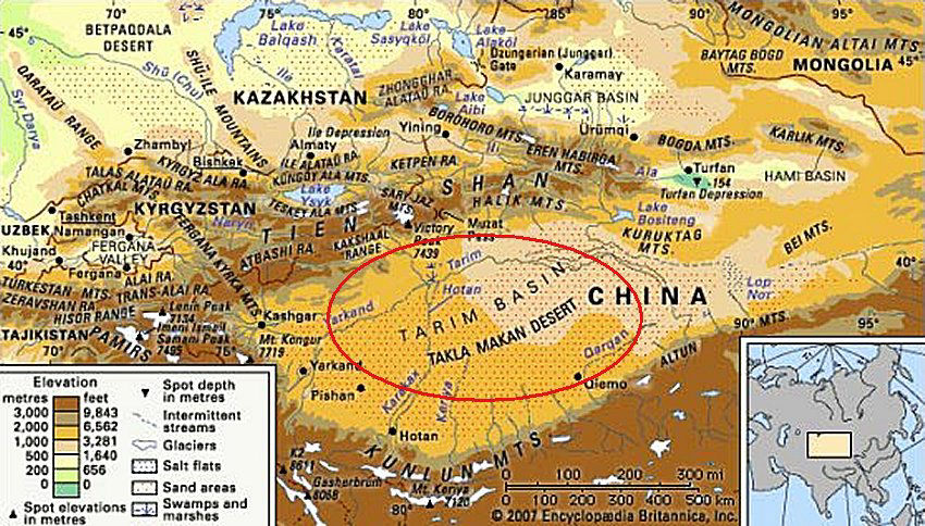
The Taklamakan Desert
Source
This is the largest desert in China covering some 33,700 square kilometers. Recently many residential buildings, temples and tombs have been found along with mummified human remains. Some of these remains have European features and red hair. Of course, the Bayesian dating process dictates that these findings must date back thousands of years. However, in 1901 at the oasis town of Dandan Oilik, in the heart of the Taklamakan Desert, Aurel Stein found the remains of 18 residential houses and identified some temples. “He also found documents from the Tang and Han dynasties.” Source
The Han dynasty ran from 206 BC – 220 (the 3rd century phantom cataclysm) and the Tang dynasty from 618 – 907 (the actual 10th century cataclysm), both are described as “golden ages" although if we apply Heinsohn’s adjustments we find that they are one golden age repeated and wiped out in the early 10th century. Therefore, we can date the formation of the Taklamakan Desert to the 934 cataclysm.
“Leptis Magna in Lybia was the place where the Roman emperor Septimus Severus was born. He turned it into a gigantic city and one of the most important parts of his empire, but when Rome started to fall, Leptis Magna fell with it. It was pillaged by raiders, destroyed by Arab invaders, left in ruins, and completely forgotten until it was buried under the drifting sands. Leptis Magna spent about 1,200 years buried under sand" Source
Here we have another highly sophisticated "Roman" city that was “buried in a sandstorm” and lost for a millennium. When it was rediscovered in the 19th century it was almost completely intact with an amphitheatre, baths, a basilica, and a circus. As usual the Wikipedia page gives its garbled explanations that include all the same elements that we found in the Timgad entry - which I’m not going to bother repeating. At the end of it they conclude by stating that, “By the 10th century, the city of Al-Khums had fully absorbed it” which is ridiculous because it was buried under sand, not under the city of Al-Khums.
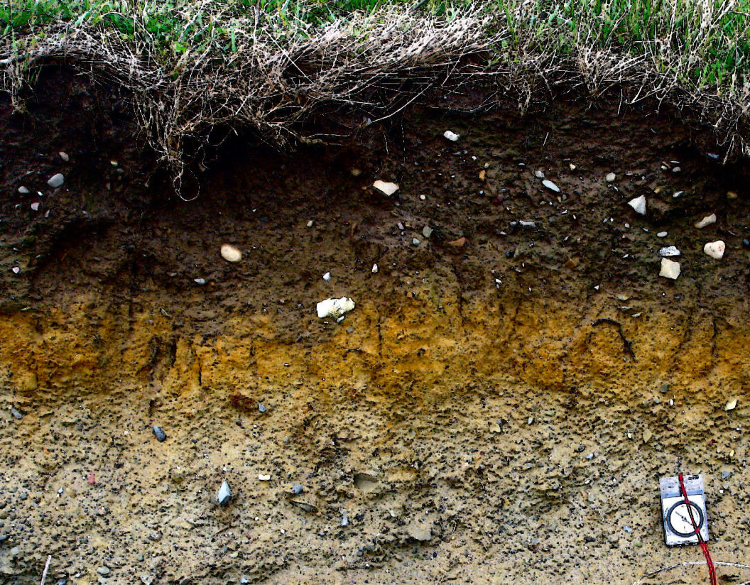
As we have seen, the sheer quantity of muck / dark earth / peat and sand that appeared on the Earth is unimaginable. At some places within the Arctic Circle it’s well over one kilometre deep. To assume that it all ended up on dry land and not in the seas, lakes and rivers would be a bit naive. If we accept that the North Pole region was the epicentre of the phenomena, then the ‘blast area’ must have encompassed the entire northern hemisphere at least. Obviously, if comparable quantities of dark earth fell into the oceans over that same ‘blast area’, then an equivalent quantity of additional material ended up on the ocean floors, in lakes and in rivers that could not help but displace the water. The inevitable consequence of this must have been a rise in sea levels and the creation of bogs or marshland where there were once lakes plus a strangulation of rivers that would also carry even more dark earth down to the mouths of those rivers along the coastlines. This is evident from the vast quantity of intertidal peatlands around Britain’s coasts that so interest The English History organisation.
The islands around the North Pole are a favourite topic on conjuringthepast.com and have featured in quite a few of our articles. However, this time they are more relevant than ever, being at the very heart of the matter. You won’t find them on any modern maps though. A detailed description of them can be found here
The Mercator map of the Septentrional Isles was based upon information given in a book called ‘The Inventio Fortunata’ which is long lost, of course. The strange saga of this book can be found in the same article referenced above. It’s my belief that it depicts the North Pole as it was before the 934 cataclysm.
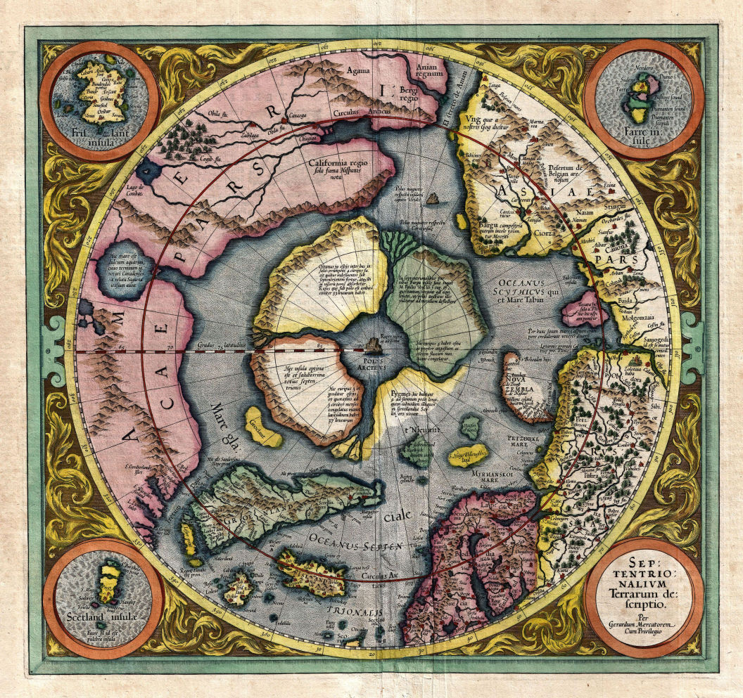
Mercator's Polar Insert, 1606 version
Public domain
In Felix’s article, referenced above, the phenomena of the tidal respiration of the Earth was explained whereby the waters of the oceans are drawn into a whirlpool at the North Pole beneath the magnetic mountain of Rupus Negra and then later expelled once again. As Felix demonstrated in the link above, it wasn’t only Gerardus Mercator and Dr. John Dee who believed this to be true, there were many others before them.
On Mercator’s map the “Upper left, describes 4 rivers with 19 openings to the ocean, All flow north and empty into the central sea then pass to the inner earth through a 33 league (114 mile/183 km) wide canyon below the mountain.” Source
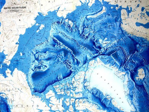
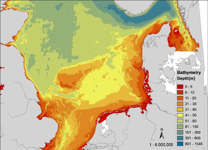
If this is an accurate and true description of the mechanics behind the world’s tides (and I’m sure the majority of people will dispute it out of hand,) then imagine the chaos that would be caused following untold billions of tons of dark earth being dumped on the entire area. The tidal respiration would be suffocated along with the rise in sea levels caused by the inundation of all that dark earth. In fact, you might expect to see something like this:
This is what they call a bathymetric image and the one above was put together recently. It’s still possible to make out the 4 main rivers or ‘indrawing seas’.
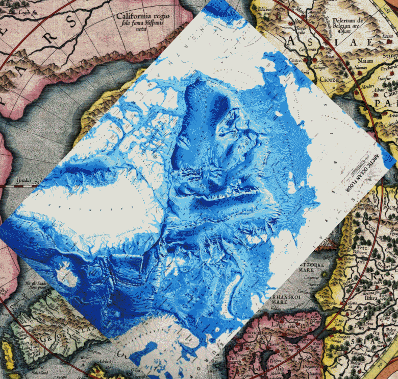
The bathymetric image had to be skewed in order to align it with the map, but then only the centre of the image is north, every other direction is south, nevertheless, in my opinion it’s a close match, in fact much closer than I could ever have imagined given that Mercator was working from written information.
A major aspect of Historic England’s activities (who were mentioned earlier in relation to their Bayesian Processes,) are related to the intertidal and costal peatlands of the UK of which there are many. “Understanding and protecting England’s peatlands helps both heritage and mitigating climate change,” they say, using extremely bad grammar as well as the climate change meme.
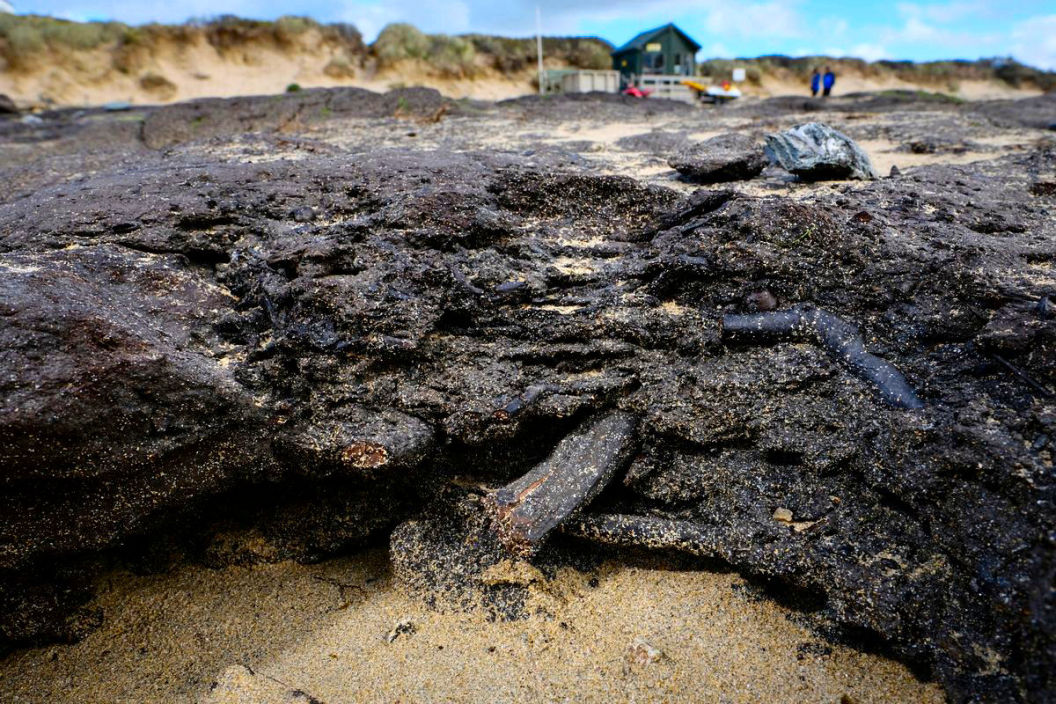
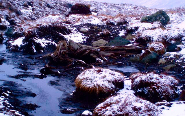
A layer of peat at Mawgan Porth beach, Newquay, Cornwall, UK
Source
The above image shows a layer of peat covering an ancient forest, or rather the remains of what was once an ancient forest. This area in particular was uncovered by a recent storm, but evidence of the ancient forest in this area has been revealed before when it was mentioned in an 1839 book by Henry Thomas De La Beche who’s report on the geology of Cornwall, Devon and west Somerset recorded “traces of submarine forests" around Mawgan Porth.
As usual there is much debate and confusion regarding the dating of this forest, but the mainstream opinion is 6000 - 4000 BC.The peat itself has recently been carbon dated to 300 - 400 AD, which is a bit embarrassing, therefore a new theory has been improvised whereby the forest ‘debris’ was washed down onto the shore “thanks to Cornwall’s early tin streamers” some 1700 years ago. I wonder if this new dating and theory was the result of Bayesian statistics?
According to the ‘Cornwall & Isles of Scilly Historic Environment Record’:
“The Cornish coast has many sites of submerged forests, the remains of past vegetation and land surfaces preserved in intertidal peat deposits, Mounts Bay perhaps being one of the most well known.”
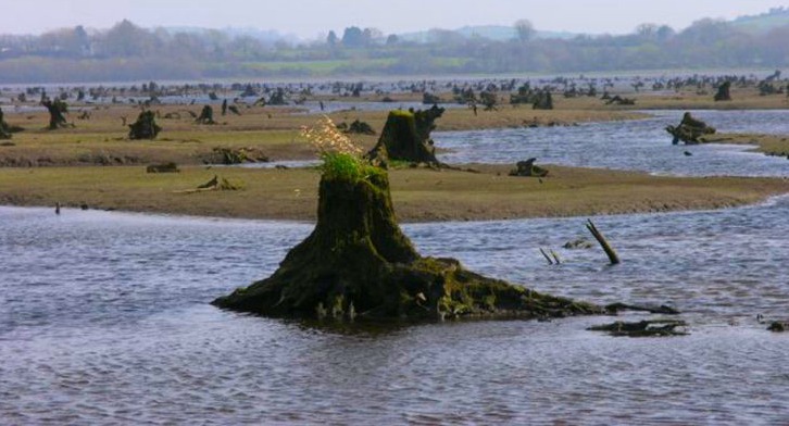
Sunken forest County Cork, Ireland
Hywel Williams, CC BY-SA 2.0
These submerged forests exist all around the coast of the UK. There are hundreds of printed reports available on Historic England’s website and they make interesting reading.
They are of varying competence, but the vast majority speak of forests with trees still standing or of complete recumbent trunks lying in the peat. Some speak of 3 layers of peat separated by an unspecified thickness of clay or other silt. Example:
Location description: 300 yards [274.32 m] below [seaward from] full-sea-mark.
Deposit description: Submerged forest in the sandy beach between the Mount and Penzance. Trunks of several large trees in their natural position - oak, willow and hazel. Earth in which roots were growing contained Juncus remains.
Deposit stratigraphy: 10" [25.4 cm] of sand on top of the marsh-earth in which the trees were situated.
Also:
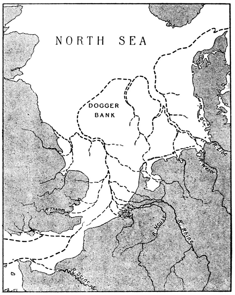
Southeastern margin of Dogger Bank, North Sea, Authors / Year: Veenstra, H. 1965
Deposit description: Peat.
Notes: 14C age is from Jelgersma (1961). Subsequent accumulation rates are calculated as an average of 0.3 mm/year.
Age: 9300 14C years BP
So they took the Carbon 14 dating from an entirely different sample and adjusted it to the thickness of the new sample by using the calculation of 0.3 mm of peat equals one year… genius.
Another entry states:
Description: Record ID 575 [Core from] Peat layer.
Carbon 14 Age of sample at 215mm in core 8720 ± 90 BP
Carbon 14 Age of sample at 140 cm in core 9210 ± 90 BP (above previous sample.)
Notes: Omitted as too old.
In general, all the samples that have been carbon dated show no consistency regarding the depths within the samples at which they were laying. The dates range between 7500-12000 years ‘Before Present’ (1950 is the present apparently because after that all the nuclear weapon tests messed up the carbon 14 levels.) Quaternary, Pleistocene, and Holocene are all mentioned a lot as these are the key jargon words in their carefully constructed geological pantomime that begins with the melting of the Ice Age and coincides with the dawn of the human race. “Oh no it didn’t!” “Oh yes it did!” etc...
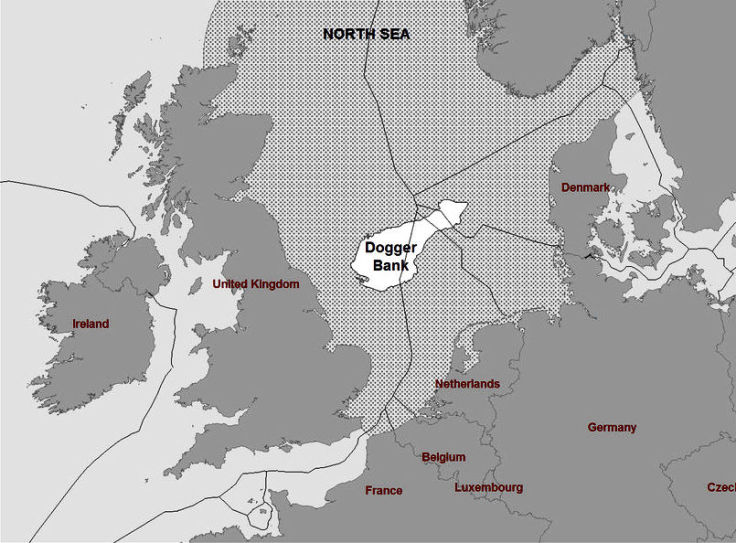
We have already mentioned Dogger Bank in the North Sea when showing examples from the archives of English History’s peatland database, which described tree stumps, peat and ‘moorlog’ trawled up from from a depth of 40 – 50 metres. Moorlog is an old trawler-man's term for a mass of peat and wood from the seabed that would get caught in their fishing nets far more often than they would have liked. ‘Dogger’ means "two-masted fishing boat." Another colloquial term is ‘Noah's woods’. This was the name given to the numerous submerged forests in the North Sea and all around the British coast. They were thought to be remnants of the biblical flood and the term dates from a time before all the clever scientists and geologists took out their pleistocene and moulded pre-history into a complex Bayesian model involving millions of years, dinosaurs and Ice Ages.
“For the last 50 years [before 1913] it has been known to geologists that the bed of the North Sea yields numerous bones of large land animals, belonging in great part to extinct species. These were first obtained by oyster-dredgers, and later by trawlers.
“In the middle of the North Sea lies the extensive shoal known as the Dogger Bank, about 60 or 70 miles from the nearest land. This shoal forms a wide irregular plateau having an area nearly as big as Denmark. Over it for the most part the sea has a depth of only 50 or 60 feet; all round its edge it slopes somewhat abruptly into deeper water, about 150 feet in the south, east, and west, but much deeper on the north. This peculiar bank has been explained as an eastward submerged continuation of the Oolite escarpment of Yorkshire; or, alternatively, as a mere shoal accumulated through the effects of some tidal eddy; but neither of these explanations will hold, for Oolitic rocks do not occur there, and the bank has a core quite unlike the sand of the North Sea.
“When trawlers first visited the Dogger Bank its surface seems to have been strewn with large bones of land animals and loose masses of peat, known to the fishermen as "moorlog," and there were also many erratic blocks [miscellaneous lumps of stone or rock] in the neighbourhood. As all this refuse did much damage to the trawls, and bruised the fish, the erratics and bones were thrown into deeper water, and the large cakes of moorlog were broken in pieces. A few of the erratics and some of the bones were however brought to Yarmouth as curiosities. Now the whole surface of the Dogger Bank has been gone over again and again by the trawlers, and very few of the fossil bones are found; unfortunately no record seems to have been kept as to the exact place where these bones were trawled.
“...With regard to the moorlog itself and its contents, it is possible that some of the mammals in the list, such as the reindeer, beaver, and walrus, may belong to this [the] upper deposit [layer]; but we have no means of distinguishing them, as the bones were all found loose and free from the matrix. ” Source Reid, C. 1913 'Submerged forests', Cambridge: Cambridge University Press.
The species of land animals found were: bear; wolf; hyaena; Irish elk; reindeer; red-deer; wild ox; bison; horse; woolly rhinoceros; mammoth; beaver and walrus. Very similar to those found in Alaska and Siberia. That they “were all found loose and free from the matrix,” rather than neatly filed in their appropriate Bayesian layers according to their official extinction dates, is again reminiscent of the Arctic cataclysmic evidence.
The above quote comes from a book for which I delayed the publishing of this article so that I could read it beforehand. It’s an excellent resource for the sunken forest phenomena, although the author labours under the restraints of the official narrative and chronology. This often leads him into confusion and unsolvable problems…
“if the slabs of very modern-looking peat, containing only plants and insects still living in Britain, come from such a depth, out of what older deposit can the Pleistocene mammals, such as elephant, rhinoceros, and hyaena, have been washed?” (ibid.)
Gwen and James Anderson Public domain
The presence of multiple peat layers is something that occurs often, although the number of layers isn’t consistent across the whole range of locations where data is available. This could indicate anything from two separate ‘dark earth’ events to one textbook Holocene event and the later 10th century one. Also, the effect of billions of tons of dark earth appearing on the land and in the sea is absolutely unknown in terms of how the sea would behave under such conditions. In fact, I’m simply assuming that it fell from the sky because it’s the most likely scenario next to the official line of taking thousands of years to grow, which is ludicrous in relation to the 10th century cataclysm.
Borth Beach, Ceredigion , Wales. This forest has for years been associated with myths about a Welsh Atlantis - Cantre’r Gwaelod (The Sunken Hundred) featured in 13th century literature.
Eveengland, CC BY-SA 4.0
The same situation of a jumbled mess occurs with regard to sunken forests:
“During the excavation of certain deep dykes for the purpose of draining the fens there was discovered at a depth of about 10 feet below the surface a forest of oaks, with their roots imbedded in the underlying Kimmeridge Clay. The trunks were broken off at a height of about three feet. Some of the fallen trees were of fine proportion, measuring three feet in diameter, quite straight and seldom forked. At an average height of two feet above this “forest No. 1" the remains of another were found (in the peat) consisting of oaks and yews. Three feet above “forest No. 2" lay the remains of another, in which the trees are all Scotch firs, some of which were three feet in diameter. Above this and near to the surface was seen a still newer forest of small firs. The peat close to the surface contains remains of sallow and alder, and was formed with the sea at its present level.” (ibid.)
Mr. Reid is at a loss to explain this, but it indicates a similar kind of violent upheaval to that witnessed in the reports from Alaska.
This book offers great insight into the processes involved in silt deposits made by rivers and also the formation of marshland through the encroachment of the sea. However, by far the most fascinating part is in regard to the geography of northern Europe prior to the event that caused the sea to rise. Of course, the author regards this event as being a sinking of the land rather than a rise of the sea and places it in the predefined Holocene episode of the popular Bayesian Geological series. The evidence for its occurrence, regardless of cause or time-frame, is compelling and its consequences are far-reaching.
Dove Point, on the Cheshire coast (1913)
'Submerged Forests' by Clement Reid, Public domain
“The Dogger Bank once formed the northern edge of a great alluvial plain, occupying what is now the southern half of the North Sea, and stretching across to Holland and Denmark. If we go beyond the Dogger Bank and seek for answers to these questions on the further shore, we find moorlog washed up abundantly on the coasts of both Holland and Denmark, and it has evidently been torn off submerged ledges like those of the Bank.
“Numerous borings in Holland give us still further information, for they show that beneath the wide alluvial plain, which lies close to the level of the sea, there exists a considerable thickness of modern strata ...the lowest submerged land-surface is found in Holland at just about the same depth as it occurs in England, and probably on the Dogger Bank also.
“This appearance of two distinct and thick peat-beds, underlain, separated, and overlaid by marine deposits, seems to characterise great part of the Dutch plain. It points to a long period of subsidence [WS: or two innundations], broken by two intervals of stationary sea-level, when peat-mosses flourished and spread far and wide [WS: or were dumped] over the flat, interspersed with shallow lakes, like the Norfolk broads.
“The enclosed and almost tideless Baltic apparently tells the same story, for at Rostock at its southern end, a submerged peat-bed has been met with at a depth of 46 feet.” (ibid.)
Mr. Reid goes on to show how the presence of freshwater molluscs and pollen from plants that are not associated with a coast environment, are found deposited along the estuaries of the river Thames and also those to the north as far as The Wash indicating that they were once inland rivers far from the coastline. Furthermore, given the evidence from Dogger Bank and the surrounding area, the Thames was connected to the river Rhine and probably with the Elbe. Prior to the cataclysm of the 10th century the southern part of the North Sea connected Britain with Holland, Germany and Denmark, and to some extent with France. This obviously included Scotland, Wales and maybe even Ireland.
“...for authors of the 9 th century AD, like Harun ibn Yahya, a Syrian traveler writing in 866, there is no doubt that Britain (Bartīniyah) is the ‘the last of the lands of the Greeks [Rum/Romans], and there is no civilization beyond them’ (Green 2016). That statement is later borrowed by the unknown author of the Persian Hudud al-'Alam (982 AD) in which Britain (al-Baritiniya) ‘is the last land of Rum [Rome] on the coast of the Ocean’ (Watson 2001).” Source: ‘Arthur Of Camelot And Aththe-Domaros Of Camulodunum’, Gunnar Heinsohn (15 June 2017)
Please note: Britain is described above as “the last of the lands of the Greeks” and “ the last land of Rum [Rome] on the coast of the Ocean”, BUT not as an island. "Rum" is always assumed to mean Rome, but as we shall see in the next installment, that may well be an incorrect assumption. Also, Ireland is a civilisation beyond Britain that was well known at the time, but it doesn't get mentioned as being a separate land.
Reid, C. 1913 'Submerged Forests', Cambridge: Cambridge University Press.
The same situation applies to the rest of the northern European coastline – it was entirely different:
“In the days whilst the subsidence was in progress [WS: days before the inundation] Cornwall was essentially a country of fjords, though now good harbours are few or blocked with sandbanks.
“...the alluvial flat of Mount's Bay, under which the submerged forest lies, formerly extended much further seaward; and old writers mention the tradition that St Michael's Mount formerly rose as an isolated rock in a wood. As far as can be calculated from its known rate of encroachment, the sea cannot have reached the Mount till long after the Roman period, and the legend is probably quite accurate. The Mount was surrounded by a wide marshy flat covered with alders and willows 'til well within the historic period; the contradictory story, that the Phoenician traded to St Michael's Mount for tin seems to be the invention of a sixteenth-century antiquary.” (ibid.)
The Isle of Wight and the Channel Islands were also connected to their respective mainlands, whilst the English Channel was much narrower and gave no access to the North Sea being blocked at the location of what are now the Straits of Dover - and significantly, the Channel Tunnel.
“One of the most interesting of the submerged forests seen between tide-marks on the French coast was that discovered a few years since by Monsieur Emil Gadeceau in Belle Ile. This island lies off the mouth of the Loire, and its position some way from the coast and well out in the Atlantic induced him to make a special study of its flora.
“The results were somewhat surprising; out of about 30 species sufficiently well preserved for identification, six were no longer living in Belle Ile, though known in Western France. The whole flora might have come from the north of England, characteristic French species being entirely missing, though this element is fairly represented in the living flora of the island. In short, the flora is a northern one, though in no degree arctic, and in this it agrees well with the poor assemblage commonly found in the submerged forests of the south of England.” (ibid.)
This agrees with the evidence from the village discovered under the peat in Northern Ireland. It confirms that the northern hemisphere's climate was much more uniform and lacked the extremes that we take for granted today. It also agrees with the discovery of freshwater molluscs within the Arctic muck, which shows that there was no such thing as an arctic climate before the cataclysm.
Submerged forest of Uozu, Japan, 1936
港湾協会第九回通常総会富山準備委員会, Public domain
Mr. Reid’s extensive studies led him to the conclusion that the sea level had risen by 90 feet (27.43m) either due to a subsidence of the land or a rise in the general sea level. He favoured the subsidence theory.
In Scotland and Scandinavia the evidence he found was interpreted in a different way. These areas have many ‘Raised Beaches’ which led him to conclude that the land had risen and tilted in these areas. However, the whole concept of ‘Raised Beaches’ is controversial as they are found all over the world – even along the south coast of England. I don’t want to get into that debate now, but information is available here:
Raised Beaches – archaeological pseudoscience?
Raised beaches around the world
Even after all of his research Mr. Reid was left with nagging doubts…
“Both the movements of submergence and the intervening periods of vegetable growth seem to require great lapses of time. On closer study, however, the evidence seems scarcely to support this view, for estuarine silts are deposits of exceptionally rapid growth, and one finds that the usual characteristic of “submerged forest" is that it shows indications of only a single generation of trees. The trees also are usually small, except where the submerged forest rests directly on deposits of much earlier date, or on solid rock.” (ibid)
In chapter one of ‘A Quest for the Lost Realm of Faërie’ we discussed the mythical land of Hy Brazil which made its appearances just off the west coast of Ireland. Well, if you take a look at this contour map just to the west of Ireland, above where it says ‘Porcupine Seabright’ there’s a shallow area in exactly the right spot. It’s at 200 metres below sea level, but then Atlantis was supposed to have sunk.
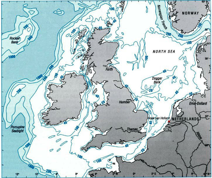
(Depths in metres)
Source
The lost land of Lyonesse lies in the Atlantic off of Land’s End in Cornwall, UK. It was immortalised in Alfred Lord Tennyson’s poem ‘Morte d’Arthur’ as the location of the king’s last battle against Mordred. It is said to have been swallowed up by the sea and disappeared in one night, never to be seen again.
“The catastrophe left only two survivors - a man called Trevillian and his white horse.
“Since then, local fishermen have been said to have pulled up stones from the buildings of the lost city in their nets and, to this day, the bells of long-submerged churches can be heard ringing beneath the waves on still nights.
“Others say the domes and spires of Lyonesse can be seen in the sea when standing on the cliffs at Land’s End.” Source
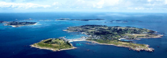
In 2016 The Lyonesse Project was instigated to study the impact of rising sea levels on the Isles of Scilly over the past 12,000 years. Of course the Isles of Scilly are in the exact same location as Lyonesse. The project came up with the usual Bayesian chronology for the inundation of the Isles of Scilly, which is no surprise as it was commissioned by Historic England who made full use of their Scientific Dating Team and its Bayesian Process.
In a more recent conflicting study it’s claimed that “The Isles of Scilly were one big island 1,000 years ago.” Source
“A thousand years ago, the breathtaking Isles of Scilly were actually a single, large island.
“Researchers studying coastal changes due to sea-level rise recently found that today's Isles of Scilly emerged from a single island. It only became the current configuration of more than 140 islands less than 1,000 years ago.” (ibid.)
Warning: If you read that article that's been quoted above, you will get mightily confused as it manages to merge the conflicting dates from both projects into one and ends up making no sense whatsoever. What is clear though is that Isles of Scilly are the higher parts of Lyonesse that became islands 1000 years ago. It’s my belief that the same situation applies throughout the coastal areas of the UK (and many other northern countries), particularly in the area of the Scottish Isles.
The Storegga Slide refers to a series of underwater landslides that allegedly took place some 8,000 years ago. They took place underwater approximately 100 kms north of the Norwegian coastline off of Kristiansund, Molde and Ålesund. The slide was from the shallower Norwegian continental shelf into the deeper Norwegian Sea area. In other words the land slid in a north-westerly direction from the shelf and yet the tsunamis hit the Norwegian coast to the south-east – in the exact opposite direction of the slide – and also Scotland to the south west.
Of course, I’m no expert, but I’d like to see a demonstration of how that might work in the real world. It appears that submarine landslides and their accompanying tsunamis are becoming quite fashionable as a means of scaring the bejesus out of everyone, which seems to be a major priority these days, not forgetting, of course that it’s a sure way of gaining funding and grants for climate change studies.
The evidence for these Storegga Slides consists of the following…
“Sand deposits of Storegga age overlie the remains of coastal settlements in Norway and Scotland.” Source
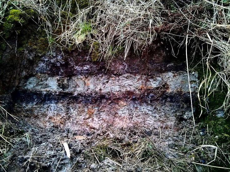
Stozy10, CC BY-SA 3.0 Public domain
The above is a photo of one such sand deposit layer taken at the Montrose Basin, Maryton, right on the east coast of Scotland. What you are looking at is a layer of sand within a peat sandwich. Below the sand is an unspecified depth of peat and above it lies another layer of peat that comprises the surface of the land. I suspect they deduced the 8,000 year date of the tsunami from the depth of the peat layer above it. The peat layer below the sand must represent “the remains of coastal settlements in Norway and Scotland”… i.e. nothing at all.
They have also managed to map the height of the tsunami(s) throughout the area, maybe by the thickness of the sand layer. They have also decided that it happened in late autumn by examining the growth stage of moss stems immediately below the sand layer. However, this assumes that the moss grew under the exact same climatic conditions as we have today and not on the back of a comet or somewhere else.
Now, far be it from me to say that these highly trained researchers are wrong. However, if an unimaginable quantity of dark earth materialised upon the northern hemisphere in 934 it might show up as the lower peat layer in the above photo. If the same quantity of dark earth fell into the ocean at the same time, then it might just cause a dramatic and sudden rise in sea levels – like a tsunami in fact – and it might leave a layer like the middle one in the above photo. Then, if the sea level subsided after the initial shock wave caused by the dark earth in the ocean, it might deposit another layer of peat as sediment when the water drained back off the land and into the sea, which might show up as the upper layer in the photograph... but what do I know?
Storegga Slide links:
Geoscienceworld.org
Lifeinnorway.net - Storegga Slide
In his ‘Nature of the Beast’ series, Felix discussed ‘Fortean’ phenomena or events that are anomalous and cannot be explained by conventional disciplines. I think this cataclysm fits into the Fortean classification perfectly. I would like to see if there were any other such events surrounding or accompanying the cataclysm that may broaden the spectrum of investigation.
We need to bear in mind that the sources of the following information may not be reliable and the chronology is certainly a real mess, as what we consider to be the first millennium actually began in about the 8th century, but we will persevere and see if anything coherent comes out at the other end.
“...between the year 1 and the 930s AD—there are only enough building strata with streets, residential quarters, latrines, aqueducts etc. for a period of some 230 Roman years in Britain. Since they are contingent with the High Middle Ages of the 10 th century AD, these massive Roman strata cannot help but belong to the 8 th -10 th century period, whatever the textbook chronology requires.” Source: ‘Arthur of Camelot and Aththe-Domaros of Camulodunum’ Gunnar Heinsohn 2017
So, according to Heinsohn, any Roman activity in Britain belongs to the period 700 – 934. He also states that the stratigraphic building layers of Rome are identical to those of Britain, therefore all Roman activity belongs to the same period. Elsewhere he qualifies this as Imperial Roman activity and claims that prior to 700, Rome was a Republic. Personally, I have a problem with that. Obviously, Rome can't have been born as an Empire - it had to be something else first, either a monarchy or a republic. However, why would the fledgling Roman Empire choose to try and conquer Britain as its first province? Presumably, at that time they didn't have a multitude of legions manned by slave soldiers because they hadn't conquered anywhere else yet. Starting off with a few places closer to home would make much more sense and yet the archaeology seems to indicate that Roman Imperial activity took place at the same time in both Rome and Britain.
We will be returning to this yopic later in the article. In the meantime, hopefully the nature of the events described below and a bit of common sense will indicate their correct placement - although, let's not rule out the possibility that some may have been relocated from later centuries or completely fictitious.
The vast majority of the following information comes from an excellent website called ‘The Gallery of Natural Phenomena’, specifically the Ancient Natural World section. The sources for the information are exhaustively listed here.
44 BC: Following the assassination of Julius Caesar, Plutarch describes a dimming of the Sun, whose orb continued pale and dull for a whole year, so that its disc could be seen without dazzlement by the naked eye. Fruits did not ripen properly. Astronomers state that an eclipse in this place and time was ‘impossible’.
9 AD: Rome had problems with revolting Germans… if you see what I mean. The first attempt to put it down was disastrous for the Romans. They were wiped out in the Teutoburgan forest, not just by the Germans, but also by an incredibly violent storm that threw treetops amongst them and also torrential rain, none of which seemed to affect the Germans.
Following the victory of the Germans The Emperor Augustus was horrified by the disaster, a catastrophe so great and sudden as this...could have been due to nothing else than the wrath of some divinity. Such was confirmed by the portents which occurred both before the defeat and afterwards and he was strongly inclined to suspect some superhuman agency." The Temple of Mars had been struck by lightning; many locusts flew into the city of Rome and were devoured by swallows. The sky to the north, above the home of the victorious enemy, was troubled.strange lights were seen in the northern sky. Three columns of fire arose from behind the peaks of the Alps; in many places the sky blazed and became filled with comet-like flames, while spears appeared to fly from the north and fall towards the Roman camps. It’s all reminiscent of a Wagnerian Opera with the Valkyries riding through the sky.
The Ride of the Valkyries
William T. Maud (1865 – 1903), Public domain
15 AD: There was another attempt to quell the revolting Germans. Again, the northern lights were seen in the form of shafts of fire falling from the skies. After an inconclusive battle with the Germans in the same forest, the Romans departed, two legions by ship and the other two returned along the shores of the Northern Ocean. A storm blew in from the north forcing the sea to rise and inundate the land adjacent to the sea. “Then the whole land became a flood: sea, shore and plain wore a single aspect; and it was impossible to distinguish solid from fluid, deep from shallow." Those that managed to survive were able to sit the night out on higher ground. By morning the storm tide had retreated.
16 AD: The Romans again attempted another assault on the Germans, but this time by sea. To this end a fleet of one thousand ships arrived in the mouth of the River Rhine. Following initial successes in July the Romans decided to retire to “winter quarters”…which seems rather odd thinking about it, but nevertheless so be it.
Before they could get underway a storm blew in from the south and scattered the Roman fleet. The tide changed and assisted the gale.
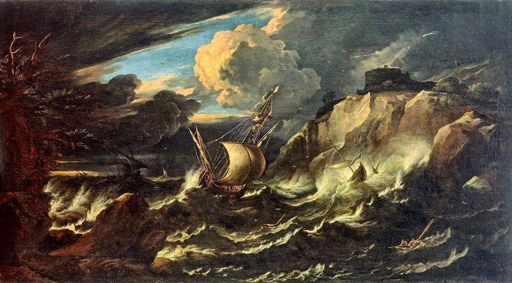
Storm at Sea
Pieter Mulier, Public domain
“Anchors would not hold; animals, baggage and weapons were thrown overboard in vain. Ships sank, or were stranded on uninhabited islands. Others were driven into the empty wastes of the World-Ocean, "a tract so vast and profound that it is believed the last and landless deep." Many soldiers marooned on remote islands died of starvation. Others survived by eating the drowned bodies of horses washed ashore. When the storm abated, crippled vessels began to come in. These were repaired, and sent out to search the islands, where they rescued a large number of survivors. Some ships had been swept over to Britain, and were returned by the petty kings of that land.” Source
It’s worth taking a brief pause at this point to recognise the implications of that last statement about “the petty kings of that land” - the Romans were supposed to have conquered Britain in 54 BC and yet there were “petty kings of that land” around who were willing to assist the Romans. The events in Germany described above, should have taken place after the time of the first Roman conquest of Britain – not 54 BC, but supposedly during the early 700’s, according to Heinsohn's stratigraphy. Therefore, this statement regarding “the petty kings of that land” confirms that the Romans had not occupied Britain at that time.
Meanwhile, back in the World Ocean…
“The crews of the vessels swept into the Ocean came back with terrifying tales of their experiences; ‘furious whirlwinds, unheard-of birds, enigmatic shapes half-human and half-bestial: things seen or things believed in a moment of terror.’" (ibid.) Another Wagnerian Opera complete with Wotan’s fury and more Valkyries.
It's interesting to consider the above account in the light of the proposed geography and climate of the pre-cataclysmic first millennium. To send a fleet of ships by sea to Germany from Rome would require sailing around the west coast of Britain, around Scotland and then down the east coast to the much more northerly Rhine estuary. Also, the early July departure for “winter quarters", seems quite superfluous given the milder pre-cataclysm climate. When considered alongside the “petty kings" remark this entire event, and its predecessor, seem completely out of place before the 10th century.
334: According to Theophanes, during the middle of the day at Antioch, a star was seen in the eastern sky, and dense smoke poured from it for three hours.
336: A ‘broom star' appeared in Andromeda in the western sky. This is believed to be the ‘hairy star of unusual size' which announced the death of the emperor Constantine on May 22nd, 337.
67 AD: An English ‘hurricane' killed many people and destroyed 15,000 houses. A hailstorm at Constantinople on July 2, is said to have killed many people and cattle. One of the hailstones filled a man's hand, and was ‘as solid as a stone'.
68 AD: Dr. Thomas Short claims that, ‘the Isle of Wight was torn from Hampshire by an Earthquake' which sounds highly unlikely. Nevertheless, in the 17th century, when an attempt was being made to drain Brading Haven – a lake on the Solent side of the Isle of Wight – a stone-cased wall was discovered near the middle, “proving that the site had once been dry land, upon which man had planted his foot,” BUT the explanation for that is much more likely to be the 10th century cataclysm.
69 AD: Lightning destroyed part of London.
394: In Antioch the form of an immense clothed woman appeared high in the night sky, seemingly lashing a whip which ‘made the air resound'. Her appearance was followed almost immediately by a ‘great and bloody insurrection' in the city.
450: August 25, in Constantinople, as Marcian assumed the crown, “the sky was dark until the evening", says John of Asia.
451: On April 3, an auroral display was seen after sunset in France, whose red streamers “were like fire or blood".
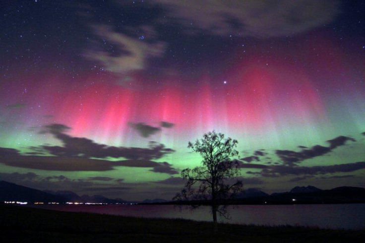
Arctic Light
Frank Olsen, CC BY-SA 3.0 Public domain
454: The auroral lights returned as fire when ‘burning pikes' appeared in the sky over central Europe.
180 to 192: during the reign of the Roman emperor, Commodus, “some stars shone continuously by day, others became elongated and seemed to hang in the middle of the sky”.
Dr. Short and John Seller claim that the 3rd century (maybe actually the 10th century?) was a period of fierce winters and eerie portents in Britain. Unfortunately, neither of these gentlemen validate their claims with source material. However, if ever there was a period when there should have been extreme weather and eerie portents in Britain then the 10th century is it.
207: Hail ‘bigger than duck's eggs' fell in Britain.
Girona, Spain, 2022
Source
530: King Arthur embarked upon his mission to the Arctic Septentrional Isles to ‘unchain the Sun’ and capture the Cauldron of Life.
418: The Anglo-Saxon Chronicle says that, “the Romans collected all the treasures that were in Britain, and some they hid in the earth, so that no one has since been able to find them; and some they carried with them into Gaul." Britain was left to fend for itself.
At this point it’s worth explaining exactly what the Anglo-Saxon Chronicle is all about. It’s not ‘a chronicle’ at all, but a collection of annals, like a diary, but yearly rather than daily. They were instigated by Alfred The Great in the late ninth century when multiple copies of the one original were distributed throughout the English monasteries and then each was independently maintained from that point onward. Today the surviving manuscripts are known as the Anglo-Saxon Chronicle and purport to tell the history of the Anglo-Saxons. However, the Winchester manuscript begins in 60 BC with Galus Julius Caesar invading Britain (even though it’s now supposed to be 54 BC... which is actually 700 AD of course.) Collectively, there are many errors, contradictions, distortions and later insertions. It seems as if it was intended as a kind of historical ‘blueprint’ to ensure that all the monasteries were singing from the same hymn-sheet, but in practical terms the good old human element sabotaged that agenda.
Interestingly, not long after the death of Alfred the Great and around the time of the cataclysm, the Chronicle(s) dry up almost totally except for four poems that have been inserted into the Chronicle. Among them, we find the Battle of Brunnanburgh, which was supposedly fought three years after the cataclysm. This ludicrous and fictitious battle “is often cited as the point of origin for English nationalism: historians such as Michael Livingston argue that the men who fought and died on that field forged a political map of the future that remains (in modernity), arguably making the Battle of Brunnanburgh one of the most significant battles in the long history not just of England, but of the whole of the British Isles." That “political map of the future” was a complete and utter fraud and far from anything that could ever be described as the origin of English nationalism. It’s probably one of the earliest cases of political manipulation on record.
The annals of the last section of the Anglo-Saxon Chronicle (960-1070) are negligible – obviously because of the cataclysm. Only two events of importance are recorded – the coming of Cnut in 1017 and the coming of William the Conqueror in 1066.
In view of this and the fact that, as we shall see later, the whole Anglo-Saxon kingdom of Britain thing is denied by the archaeological record, it is tempting to dismiss the entry regarding the Romans looting and abandoning Britain. However, there is actually archaeological evidence to support this statement which will become clear as we proceed...
230: John Seller, in his 1696 History of England, said that ‘armies of footmen and horse' were seen fighting in the sky over London and other places in England about the year A.D. 230. Thunder, tempests, and hail accompanied them.
14 AD: Dio Cassius, writing in the 3rd century, says that in 14 AD “... the Sun suffered a total eclipse and most of the sky appeared to be on fire; glowing embers fell from it and blood-red comets were seen." There was no total eclipse of the Sun scheduled for that year.
523: sky terrors returned to Britain. “Strange sights were seen of Dragons, Lions and other furious beasts fighting in the Air. In the west of Kent it rained Wheat, and soon after great Drops of Blood…"
48 AD: About ten thousand people were drowned in the great floods in the Thames Valley area of England.
60 AD: Edinburgh severely damaged by lightning; storm-swollen seas flooded the coasts of France and England.
68 AD: excessive rains in winter and a drought in summer caused a famine in Britain that lasted two years, “so that many thousands perished for want of bread".
The Baths of Titus
Giovanni Battista Piranesi, Public domain
134: * The river Thames was frozen for two months.
173: * Three-month frost in Britain; deep snow lay for 13 weeks and was followed by famine.
291: * Most British rivers were frozen for six weeks, or as some say, nine weeks.
230: * The Thames was frozen over for five weeks
220: * There was a frost in Britain lasting five months.
50 AD: * John Seller, in his 1696 ‘History of England’ claimed that the lakes and rivers of Britain froze solid from mid-November to the beginning of April, but C. E. Britton says this reference is ‘probably imaginary' …mind you I can’t find much information about him at all, he seems to have been some kind of meteorologist who compiled ‘A Meteorological Chronology to A.D. 1450’ which was published in 1937 and was also probably imaginary.
291: * Most British rivers were frozen for six weeks, or as some say, nine weeks.
[* These accounts seem to corroborate each other.]
365: July 21, just after dawn, a gigantic earthquake rocked the eastern Mediterranean. Ammianus Marcellinus described it as a “mad discord of the elements…a frightful disaster, surpassing anything related either in legend or authentic history". He says the shock was preceded by thunder and lightning, and “the whole of the solid earth was shaken and trembled". The sea withdrew from the shore, “so that in the abyss of the deep thus revealed men saw many kinds of sea-creatures stuck fast in the slime". Then the sea returned, roaring.
545: a wave (probably a tsunami) drowned many in Thrace.
441: Victor Clube and William Napier suggest that cosmic disaster struck Britain. There was widespread destruction in the island, followed by years of migration, dark skies and a dark age.
447: The Welsh Annals record Dies tenebosa sieut nox, or “Days as dark as night". On December 23, Hydatius records a solar eclipse, and the Annals of Lund say that “a dark day occurred".
450 to 500: Britain was desolated during this time. Roman towns were abandoned. In Cirencester unburied corpses lay in the main street. At Wroxeter, people sheltered in the heating channels below the town baths, and died there.
551: July 9, the entire eastern Mediterranean was shaken, and cities fell in ruin from Syria to Phoencia. The sea withdrew for miles, then poured over the coast in another seismic sea wave.
552: it was the turn of Greece, where towns were wrecked by earthquake and a sea wave broke over the coast. On ebbing, it “left innumerable unknown Fishes on the Shore.”
555: At dawn on August 15,shocks began in Constantinople “and many other parts of the world", which lasted 40 days. The city of Berytus (Beirut) was ruined.
The Appian Way
Giovanni Battista Piranesi, Public domain
233: Rain in Scotland for seven months, followed by a famine. John Seller, ‘History of England’, 1696
541: The Justinian Plague was preceded by burning skies, counterfeit Suns, “fiery battles fought in the air”, darkness by day, “and something resembling dust and ashes” which fell from the sky. Ships crewed by corpses drifted in the Mediterranean, and terrified sailors reported sea monsters off the coast of Palestine and a ghost ship of bronze rowed by headless oarsmen. Zachariah of Mitylene wrote that the disaster was “a scourge from Satan, who was ordered by God to destroy men." ...what a concept that is.
542: While the plague raged, earthquakes seemed to multiply. Stricken Constantinople was shaken on August 16.
536 to 567: Procopius describes “a grave portent" in the year 536. For the whole year “the Sun sent forth his rays without his usual brilliance, like the Moon". Cassiodorus in Italy said that in the year 536, “The Sun seems to have lost its wonted light, and seems of a bluish colour. We marvel to see no shadows of our bodies at noon, to feel the mighty vigour of the Sun's heat wasted into feebleness, and the phenomena which accompany a transitory eclipse prolonged through almost a whole year. The Moon too, even when its orb is full, is empty of its natural splendour…We have had a spring without mildness and a summer without heat. The crops have been chilled by north winds, (and) the rain is denied". Nor was this obscuration confined to Italy. John the Lydian recorded that “the Sun became dim for nearly the whole year". On March 24 in Constantinople, the Sun was darkened by day and the Moon by night. This lasted over a year, until June 24 of 537. In Mesopotamia the Sun was darkened for 18 months. Each day it shone for only a few hours, “and still this light was only a feeble shadow…the fruits did not ripen and the wine tasted like sour grapes". In China, “the stars were lost from view for three months", and yellow dust fell like snow. The winter of 536 - 537 in Mesopotamia was unusually severe. A “large and unwonted quantity of snow" killed the birds there and caused distress to men.
Trees all over the Northern Hemisphere were stunted by cold and drought. Sierra Nevada (Andalucia, Spain) tree rings show that the years 535, 536 and 541 were the second, third and forth coldest years in the last two millennia. The rings from Swedish pines indicate that 536 had the second coldest summer of the last 1,500 years.
535: Drought in China, which was afflicting the north of the country in the spring, became more severe. Yellow dust from the parched lands swept south, and fell like snow.
536 to 538: There were summer snows and frosts, drought and famine in China. In one province seven out of every ten people starved to death in 536, and the survivors ate corpses.
398: Jerome says the Sun was obscured “about the days of Pentecost" in Bethlehem, “and everyone feared that the day of judgement was already at hand". A solar eclipse is not possible on the day of Pentecost. Also, “a thing like a burning globe, presenting a sword" shone in the sky over Constantinople. It seemed almost to touch the earth from the zenith.
Ruins of the Soldier's quarters at Hadrian's Villa in Tivoli
Giovanni Battista Piranesi, Public domain
401: A fearsome winter froze the Black Sea for 20 days, and, when it thawed, the sight of huge icebergs drifting past Constantinople terrified its inhabitants.
655 to 682: “[Cadwallader] arrived at the Armorican coast [Brittany], and went with his whole company to king Alan, the nephew of Salomon by whom he was honourably received. So that Britain, being now destitute of its ancient inhabitants, excepting a few in Wales that escaped the general mortality, became a frightful place even to the Britons themselves for eleven years after. Neither was it at the same time more favourable to the Saxons, who died in it without intermission. Notwithstanding the remainder of them, after this raging plague was ceased, according to their old custom sent word over to their countrymen, that the island of Britain was now freed of its native inhabitants, and lay open to them, if they would come over and inhabit it. As soon as they had received this information, that odious people, gathering together an innumerable multitude of men and women, arrived in Northumberland, and inhabited the provinces that lay desolate from Albania [Scotland] to Cornwall. For there was now nobody to hinder them, excepting the poor remains of the Britons, who continued together in the thickets of the woods in Wales. From that time the power of the Britons ceased in the island, and the Angles began their reign.” Source: ‘The History of the Kings of Britain’, Geoffrey of Monmouth, Book XII, Chapter 16, 1136.
543: On September 6, an earthquake “throughout the known world" destroyed half the city of Cyzicus, near the Hellespont.
340: an earthquake was “all through the East", followed in the next few years by devastating shocks in Antioch, Neocaesarea, Rhodes, and Italy. Even Rome was shaken by tremors which lasted for three days, and, according to the historian Ammianus Marcellinus, “fearful earthquakes shattered numerous cities and towns throughout Asia, Macedonia and Pontus with repeated shocks."
Ruins of the Baths of Agrippa behind the Pantheon, Rome
Giovanni Battista Piranesi, Public domain
249: It rained blood in various parts of Britain, and “a Terrible Bloody Sword" was seen in the sky after sunset for three nights when the emperor Decius came to the throne.
317 to 329: There were floods, freezes, and a blood-rain in Britain. An earthquake in Italy shattered 13 cities.
250: was the year of a severe winter in Britain which froze the Thames for nine weeks.
557: was a year ridden with earthquakes. Constantinople, Antioch, Rome and many other cities suffered; there was thunder, lightning, “subterranean noise" and shooting stars. Part of the church of Hagia Sophia in Constantinople collapsed as “the earth cried out in pain" with “clouds and rolling dust that blazed with fire at noon."
Ruins on the slopes of the Aventino on the Marmorata Road, Rome
Giovanni Battista Piranesi, Public domain
Survivors of the Tenth Century Collapse “had the feeling of living through a revolution [and] attributed it to the advent of the Anti-Christ, and presumed that they were witnessing, not the end of the ‘Dark Ages’, as the modern historian assumes, but the first signs of the end of the world” Brooke 1964, 1 f.
The most curious thing of all about the descriptions above is that none of them mention the inundation of dark earth or the rise in sea levels despite the archaeological evidence. What does that mean? The dark earth is there for all to see in the archaeological record, so it can’t be denied, therefore the only explanation possible is that the documented narratives have been censored to remove all references to it. Which seems like another ‘Fortean’ event in itself.
It also appears that the cataclysm wasn’t simply confined to 934, but that it continued for many years after, either as a continuation or as consequences of the initial event.
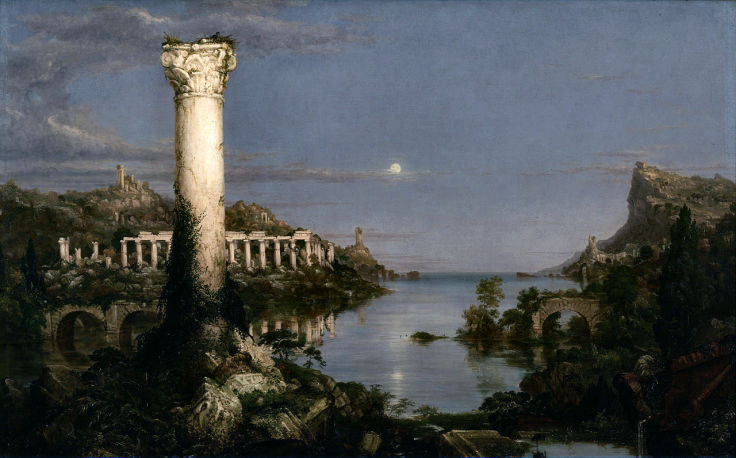
End of Empire
Thomas Cole, Public domain
It’s funny, but before Felix wrote his article about ‘The Betrayal of Albion’, including the Norman Conquest, I always thought the it was ‘The Doomsday Book’ rather than Domesday. The thing is though, it more or less means the same thing anyway, as it was a ‘judgement’ of William I’s newest possession – England. Deliberately or otherwise, it was actually a judgement, or an assessment, of the devastation caused by the cataclysm that had taken place just 150 years before.
A close examination of the Domesday Books (there were more than one) is highly revealing in terms of being the closest thing to an eye-witness account that we can expect. However, due to the extreme extent of the devastation history was forced to explain it in a mundane, acceptable way.
“Wasteland is another feature of the landscape that is recorded in Domesday, often referring to land no longer cultivated. In the border counties of Hereford and Shropshire land had sometimes been laid to waste as a result of Welsh raids before the Norman Conquest. In other instances land laid to waste after 1066 is recorded as creating space for the King’s forest.” Source
“Domesday shows to some extent the cost of the Conquest on land values, which was particularly devastating in Northern England where many small villages were destroyed or damaged so badly their land values decreased by about a quarter since 1066 (these villages were noted as ‘waste' in the Domesday Book). King William was partly to blame for his men's ruthlessness, but raiders from Ireland in Devonshire also had a bad effect on land values in the areas they passed through.” Source
(Please note, there is nowhere named Ireland in Devonshire. What they mean is Irish raiders from Ireland who passed through Devonshire and affected all the land values.)
“William’s Harrying of the North took place during the winter of 1069-1070. According to contemporary reports, the population of northern England declined 75% in those few weeks; 15 years later, the Domesday Book still described much of the region as “waste”, and Domesday has no entries at all for the area of the north that would later form Westmoreland, Cumberland, Northumberland, and the County Palatine of Durham.” Source
Jean-Achille Benouville, Public domain
OK, so we can’t use the cataclysm word so let’s blame the Welsh and also the people of the north who had the nerve to rebel against William I forcing him to send his Flemish mercenaries to kill them all and completely ravage the land in just a few weeks… in the winter… in the north in the winter. Wait a minute, what about the Danes, the Scots and of course the Irish? Read on...
“Perhaps the most striking feature of the Yorkshire folios is the very large amount of waste they record—a terrible testimony to the efficacy of ‘the harrying of the north’ by the Normans during the winter of 1069-70. Seventeen years later, the marks of this devastation were to be seen on every page of the Domesday Survey; many pages present hardly anything else." But though it was the Normans who were mainly responsible for this wasting, the ravages of the Danes and Scots in 1069 and 1070 were also partly to blame.
“As many as 196 places were wholly waste and 71 were partly waste, a total of 267 out of the 719 places recorded in the Text. In other words, between 36% and 37% of the vills in the West Riding were wholly or partly waste. And this figure is certainly on the conservative side because it makes no allowance for those fairly numerous places where, although no waste is specifically mentioned, the form of the entries suggests that probably they were also waste… This type of entry is found for some 135 places. All the vills in Craven for which waste is not specifically recorded come within this category, so that, though waste is mentioned for a third of the Craven vills only, it seems almost certain that the whole of Craven was actually waste. This means that in all probability more than one place out of every two in the West Riding was in fact wholly or partly waste.” Source: ‘The Domesday Geography of Northern England’, H. C. Darby & I. S. Maxwell, 1962.
(A ‘Vill’ was the smallest administrative unit of land in feudal England by the way and probably related to the word ‘village’.) In the North Riding of Yorkshire the figures were even worse where between 57% and 58% of the vills were wholly or partly waste and this is also a conservative estimate.
“They also suggested that some of the wasting was due to the Scots whose ravages ‘were at least as savage as the Conquerors.'” (ibid.)
Didn’t you just know it, those Scots eh? However, it’s nice to know that over the centuries some academics have noticed that something doesn’t add up...
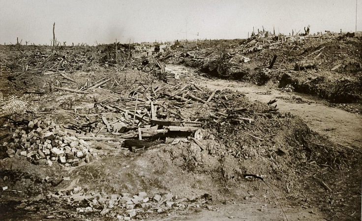
Nationaal Archief, CC0, Public domain
“Beddoe and Rowe stated that they did ‘not see how some of the greater desert tracts which have been mentioned could have progressed as they seem to have done without immigration from a distance. Some of the Norman owners had lands in other counties, whence they have transferred some of the superfluous, or at least not greatly needed, population.’” Source (ibid.)
T. A. M. Bishop concluded that there may have been no simple relationship between the routes followed by the Norman army and the areas of most waste ‘The condition of Yorkshire as a whole... must be set down mainly to the methodical destruction carried out by the French in the winter of 1069-70; but if the condition of particular areas is assumed to be directly traceable to their operations, it must appear remarkable that William's army should have indulged in no more than sporadic devastation of large parts of the plain, while carrying fire and sword to remote upland settlements.’
Finally, someone with a bit of common sense you might think...
“Bishop suggests that the waste holdings of 1086 did not indicate the tracks of the destroying armies, but that they were the result of a movement of people, between 1070 and 1086, from unfavourable areas to the wasted holdings of more fertile districts.” Source (ibid.)
Nope, false alarm.
The following is a map of the West Riding of Yorkshire according to entries in the Domesday Book and showing the devastated areas that were mostly unpopulated. If you click on it, it should open in a new tab in full size. This is just a small part of the total affected area.
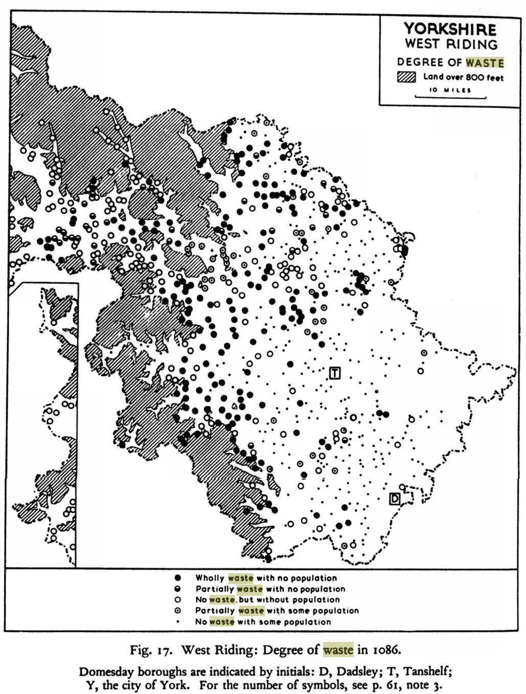
‘The Domesday Geography of Northern England’, H. C. Darby & I. S. Maxwell, 1962.
Click Image to Enlarge
It would appear that the cataclysm had a far greater effect on the northern areas of England, Wales Ireland and Scotland. This is to be expected if the epicentre was the North Pole. The devastation and desolation revealed by the Domesday Book verifies some of the post-cataclysmic descriptions in the ‘Strange goings-on in the first millennium’ section earlier.
“The author has described the Tenth Century Collapse from Yucatan via Iraq to China using many examples (Heinsohn 2017b). So it is not only the downfall of the Imperium Romanum that is mysterious, but the simultaneous end of civilizations around the globe. If you only want to understand the end of Rome and don't look at the blows all over the world, you won't find a solution.” Source: ‘Tenth Century Collapse’ by Gunnar Heinsohn, 2017.
Scandinavia, Bulgaria, the classic Maya culture of the Yucatan, Tiwanaku in Bolivia, the early Abbasids of Iraq, Constantinople, all of Ancient Egypt, the Balhae-Empire (Chinese: Bohei) stretching from North Korea via China to Manchuria, the Singhalese Anuradhapura civilization of Sri Lanka – all bear witness to the worldwide nature of this cataclysm. No doubt there is also evidence in Australia, India and The Americas, etc,. but there just isn't the time or the space to include it all - apologies.
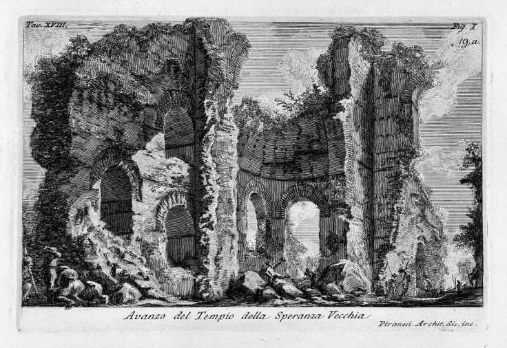
Avanzo del Tempio della Speranza Vecchia.
Giovanni Battista Piranesi, 1756, Public domain
Ever since Felix and I began researching the Arctic Circle cataclysm, some years ago now, neither of us could imagine what on earth could have caused billions of tons of ‘muck’ to appear upon the ground and then get flash-frozen almost immediately. Now, with the expansion of the event to include the practically worldwide Dark Earth phenomena and also the creation of deserts, it has served to make matters even worse in terms of beginning to conceive an explanation.
Gunnar Heinsohn has his own theories. He points to the time of Comet Heinrich-Swift-Tuttle and its coincidence with the explosion of the volcano Eldgjá in Iceland. This caused the nearby volcanos of Katla and Vatnajökull to erupt.
“After Eldgjá, around 220 million tons of sulphur dioxide were spewed into the atmosphere and, through reaction with water and oxygen, become 450 million tons of sulphuric acid, whose lethal aerosols covered the northern hemisphere” Source ‘Did Comet HEINRICH-Swift-Tuttle Terminate Roman and Global Civilization?’ G. Heinsohn, January 2021.
It’s not clear how the comet is linked to the volcanic eruptions or how ‘muck’ and / or dark earth would be the result of sulphuric acid in the atmosphere. Whilst Greenland ice-cores seem to support these eruptions, tree ring evidence throughout the northern hemisphere is “sparse.”
Comet Heinrich-Swift-Tuttle is apparently an ‘Icy body of dust and dark organic matter’…
“Every August Earth passes through a section of Swift–Tuttle's cometary tail—a cloud of particles [Perseids] ejected from the comet, most of which have been in this formation for a thousand years [https://phys.org/news/2018-08-cautionary-tail-comet-swifttuttle.html]. Swift-Tuttle is “the single most dangerous object known to humanity” (Gerrit L. Verschuur). A direct Earth hit would equal the energy of 20 million hydrogen bombs (28 times the dinosaur killer). Unusual is its orbit because it was, only 1000 years ago, captured into a 1:11 orbital resonance by Jupiter. It was the first comet in a retrograde orbit to be found in a resonance. Back-calculating Swift-Tuttle's orbital period, whose 133 years is an average and not a regular value, its appearance in the first half of the 10 th century CE is likely. If young Swift-Tuttle has been a double-headed comet ...it could have lost a head or part of it in the process... At the same time such a loss of mass would have led to a modified and therefore less dangerous orbit.’ (ibid.)
I really must apologise, but I can’t take any of this seriously. It’s no doubt due to my own personal bias, but to me it sounds like a script from Star Trek Voyager.
“Organic matter refers to substances that are composed on a fundamental molecular level from compound cells originating from plants, animals and their associated products.” Source
How can a comet of ice, dust and dark organic matter even exist in the real world? If the comet is constantly ejecting ‘Perseids’, or particles to us mere mortals, where are they coming from? Does the comet have an inexhaustible supply of dust and dark organic matter? Are there plants and animals riding on the comet?
How does a comet get captured in orbit around Jupiter and then travel close enough to the Sun for the Earth to pass through its tail (which is full of dust and dark organic matter that’s been hanging around in space for 133 years between orbits,) without getting caught by the gravitational attraction of the Sun or even the Earth or in fact any other celestial body, all of which must be much bigger than it is? (Apologies for the extra long Dickensian-style sentence.)
The flood of Noah and the companions
Léon Comerre, 1911, Public domain
The problem here is that we, as a species, don’t have any point of reference for a cataclysm of such magnitude. The only thing that comes close is the semi-mythical Biblical Flood and that involved lots of water being thrown down upon the Earth, which is much easier to get your head around than dark organic matter. It’s cause was the bad temper of an off-world deity, in other words there was no ‘scientific’ or ‘natural’ explanation, although I’m sure by now the clever-dicks have come up with a few, no doubt involving comets, meteors, asteroids, the Moon or volcanic eruptions and earthquakes.
This topic will be addressed again in future installments.
Other massive misconceptions have arisen from all of this muddle regarding ‘Bayesian Chronology’. Archaeologists let us know how clever they are by examining the pollen found within the peat which they assume to be an accurate record of the last however many thousands of years they have assumed. This then enables them to make statements regarding historical climate data, fauna and flora, as well as human habitation.
In Alaska it’s evident that the climate was totally transformed after the cataclysm. The freshwater molluscs and mammal remains, which include camels, lions, tigers, horses, bison and many more species that would not survive in current Arctic conditions confirm this.
“Though the ground is frozen for 1,900 feet (579 m) down from the surface at Prudhoe Bay [Alaska], everywhere the oil companies drilled around this area they discovered an ancient tropical forest. It was in frozen state, not in petrified state. It is between 1,100 (335 m) and 1,700 feet (518 m) down. There are palm trees, pine trees, and tropical foliage in great profusion. In fact, they found them lapped all over each other, just as though they had fallen in that position." Lindsey Williams, The Energy Non-Crisis, 2nd. Edition, 1980, p. 54
The fact that the trees and foliage were healthy rather than decayed, demonstrates that it wasn’t there because it had died ‘of natural causes’, but that it had been pushed over or knocked down. Furthermore, pine trees are not normally found in hot tropical climates (apart from maybe one rare species.) The claim of “an ancient tropical forest” may just be yet another assumption – palm trees grow in Cornwall in the UK even now which is hardly tropical. Also woolly mammoths and bison wouldn’t be properly dressed for the tropics.
What makes more sense is the evidence from the archaeology of the peat covered village of Céide Fields on the northern Irish coast mentioned earlier, whereby “The climate at the time was much warmer, leading to almost year-round growth potential. Samples taken from the remains of trees found in the bog provided evidence of this.” Source
This suggests that the overall climate, fauna and flora were far more ‘universal’ rather than varying from one extreme to the other as is the case now. I also have a quote somewhere from 1852 regarding the discovery of mammoth, lion and tiger remains in England, but I’m damned if I can find it.
The point is that the fundamental Bayesian beliefs regarding the formation of the peat bogs is totally wrong and has been the cause of complete and utter confusion regarding the history of the world we live in and the world our ancestors lived in.
This confusion has led to statements like this:
“There was a lot of pine in the pollen profile, and oak and elm were consistently present. The small amount of ericaceous pollen [from the kind of plants that grow in peat bogs] shows that bogs had not yet expanded very far. This discovery moved the accepted date for the colonisation of the Irish Midlands back over three millennia earlier. It is thus almost beyond doubt that human communities were present little more than 500 years after the end of the Ice Age throughout the landscape of lakes which preceded the bogs. We can be sure that when the large raised bogs are stripped away to reveal more ancient shorelines, more evidence of early human settlement will come to light. People came to Ireland before the bogs and their cultural evolution has thus taken place alongside the evolution of the boggy landscape, which has always played an important role in Irish cultural development.” Source
Amazingly though, the part about people being in Ireland before the bogs is actually quite correct, BUT that’s only because they wouldn’t dare to admit that the peat covered the landscape in one massive 10th century dollop rather than accumulating over thousands of years. Therefore, they have no choice but to send the date of the settlement back in time by thousands of years.
Another feature of Felix’s article ‘King Arthur in Hyperborea & the Arctic Cataclysm’ was the seemingly persistent claim that Arthur had ruled over a much larger kingdom then just Britain. Felix demonstrated that the source of this claim pre-dates the 1199 text known as ‘Insule Britannie’ and comes from a book known as ‘Gestae Arthuri’. This book was ‘lost' even in John Dee’s time, but the ‘Insule Britannie’ and also another known as ‘Leges Anglorum’ of 1210, also mention this extended kingdom, but they are ‘sanitised’ versions of the original ‘Gestae Arthuri’. However, they also include falsified incorporations from Adam of Bremen's ‘Gesta Hammaburgensis Ecclesia Pontificum’ of c. 1075, whereby the account of the Christian conversion of Norway was transferred to Arthur. Other evidence shows that it was actually begun by John, an English bishop, and spread by Olaf, king of Norway via a policy of ‘convert or die’ which inspired a mass migration to Iceland as documented in the Icelandic Sagas. At this precise time, just as the world was recovering from the cataclysm, it became necessary, as the first priority, to demonstrate that King Arthur was a mere mortal, and secondly to claim him as a Christian hero.
Anyway, it’s interesting to look at the bathymetric evidence for the area that coincides with the description of Arthur’s lost kingdom…
The lighter blue areas are the shallowest and it’s highly likely that some parts were above sea level before the 10th century cataclysm. Combined with the previous evidence for the connection between England and mainland Europe, this puts a different perspective on the general accessibility of lands beyond the British Isles as we know it today. For example, today there are over 900 islands just off the coast of Scotland and for convenience, they are grouped as the Inner and Outer Hebrides, the Orkneys and the Shetlands. These islands are full of megalithic structures and the Orkneys in particular recently caused a major upheaval in theories concerning the spread of megalithic culture, which is covered in chapter one of our ‘A Quest for the Lost Realm of Faërie’ article. The vast majority of these 900+ islands were obviously part of the mainland before the cataclysm and who knows what megalithic treasures might be hidden a few metres beneath the waves today.
From this point of view, it looks almost as if you could walk around the world in the northern hemisphere... well, paddle anyway.
So, maybe John Dee’s claim that King Arthur once ruled over a kingdom that comprised...
“...all Scantia, which is now called Norway, and all the Islands beyond Norway, to wit, Island [i.e., Iceland] and Greenland, which are apperteining vnto Norway, Sweueland, Ireland, Gotland, Denmarke, Semeland, Windland [Latin text, Winlandiam], Curland, Roe, Femeland [i.e., Finland], Wireland, Flanders, Cherilland, Lapland, and all the other lands & Islands of the East sea, euen vnto Russia (in which Lapland he placed the Easterly bounds of his Brittish Empire) and many other Islands beyond Norway, euen vnder the North pole, which are appendances of Scantia, now called Norway.” Source Richard Hakluyt, ‘Principal Nauigations’ (1599)
...isn’t so far-fetched after all.
This phenomena seems to have been very different to the one we know as the Aurora Borealis today – for a start it was visible from as far south as Rome. It’s quite relevant as the epicentre of the cataclysm was at the North Pole.
The mysterious northern lights were nothing new. In 502 BC “military spears...seen on fire in the sky late at night" were described in the records of Rome. Aristotle described how “chasms, trenches and blood-red colours" could sometimes be seen on a clear night. Whilst Aristotle spoke in general terms, without giving examples, the historians Pliny and Livy gave more details. Pliny recounts that during the time of the Roman Republic, “out of the firmament at night, there was seen a light... so as the night seemed as light as the day." Armies appeared in the sky in 103 BC (600 AD?) “The Amerines and Tudertes saw men in arms in the sky, rushing one against another from east and west; and those of the west were discomfited." According to Julius Obsequens, Livy describes this phenomena from the viewpoint at Volsinii, Italy, in the form of flames rising from the ground and reaching into the sky. The northern lights were usually seen as opposing armies in the sky during these times and their transformation into aurorae during later centuries is quite clearly defined, however, not all of these armies were aurorae.
Such events have happened since the first millennium, although not many:
Aurora Borealis by Frederic Edwin Church overlaid with The Battle of Culloden by David Morier Public domain / Jonathan Aprea
“On the night of March 6, 1716, people all over England witnessed a bloody war unfolding in the sky. Some claimed the battles were so fierce they could smell the gunpowder. Others saw flaming swords hanging in the air like Macbeth’s dagger.
“Even in the dead of night, the aurora was bright enough to read by. Sometimes the sky looked like a shattered mirror, with cracks of light running through it; at other moments the air seemed to be full of tumbling flakes of fire. To many, it seemed like the end of the world.
“...people around the country gathered to witness the scene, but although they all stared up into the same sky, they interpreted what they saw in dramatically different ways. Some saw supernatural soldiers slaughtering each other in the air. Others saw simply a natural oddity, a particularly vivid version of the Northern Lights.” Source
Perhaps it’s something about us that’s changed since the end of the first millennium, rather than the Northern Lights?
Seneca actually classified the different types of aurora. He was writing based upon his observations made in Corsica and/or Rome by the way...
Today the Aurora Borealis is a comparatively local phenomena and consists of intermingled veils of mainly green and turquoise light. In Seneca’s time 4 BC – 65 AD (695 – 770?) he described the aurora as having red, white, and yellow colours and how it was sometimes interspersed with outbursts and rays, plus it was also visible from the Mediterreanean.
It’s curious to compare the storms in the events described above with those discussed in the article ‘The Great Storm, The Black Alchemist & Toxic Ley Lines’ wherein the long tradition of the conjuring of storms is revealed. For example: the storm that defeated the invasion of the Spanish Armada, generally attributed to Dr. John Dee; Shakespeare’s depiction of Prospero in his play ‘The Tempest’ (who was probably based on John Dee); Gerald Gardner’s account of the New Forest witches who conjured up a storm to prevent a German invasion during WWII and the storms that were conjured up to thwart Julius Caesar’s allaeged Roman 55BC – 54BC (circa 700 AD) invasions of Britain, which were much like those that the Germans used against the Romans during their 9 AD –16 AD (713 – 720) revolt. This subject is discussed in detail in the article ‘The Great Storm, The Black Alchemist & Toxic Ley Lines’.
Circe Conjuring a Storm
Frederick Stuart Church, Public domain
The greatest obstacle to any attempt to demystify what happened in the past is the barrier of our own pre-conceptions - it seems we have our own ingrained Bayesian Process. Violence, conflict, barbarism and mental deficiency are the only virtues we ascribe to our ancestors and their sole preoccupation was war, conquest, and greed – the old ‘rape and pilliage’ routine. This is exactly how we’ve been indoctrinated. We’ve already seen this in action with regard to the Bog Bodies and artifacts. In spite of the arrogant superiority of our factual scientific ego, perhaps we’re simply transferring our own corrupted nature onto our ancestors.
Take for example Hadrian’s Wall in the UK, said to be the northern-most frontier of the Roman Empire. We all know the official story, especially the Brits amongst us. Well, whilst we all thought it represented the last bastion of the civilised world against the blue-painted, naked barbarians of the north, the archaeology is beginning to tell a very different story…
“An area of 1,500 square kilometres (579 square miles) was explored in the area beyond Burnswark using LiDAR (Light Detection and Ranging) drones, which is essentially 3-D laser scanning. The support of the British academy was enlisted, helping reveal a total of 134 indigenous Iron Age “Hadrian’s Wall settlements” in the region, which had not been recorded before. Researchers believe at least 700 such settlements lay hidden beneath the project’s study area.
“The research results indicate a dense distribution of highly-organized settlement sites dispersed across the region. Small farmsteads were the norm for the majority of these indigenous settlers.” Source
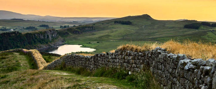
Hadrian's Wall
Source
“Indigenous Iron Age ‘Hadrian’s Wall settlements’”… Hadrian’s Wall wasn’t built in the Iron Age – or was it? I don’t want to get distracted again but personally I believe that Hadrian’s Wall, the earthwork barrier known as the Vallum just to the south and the Antonine ‘Wall’ (which wasn’t a wall, but another earthwork and 160 kms to the north of the solid wall,) were all actually constructed in the reverse order. The point being that whoever built these was coming from the north and defending themselves against the south. The Antonine Wall came first, then later the Vallum earthwork was built at the same time as Hadrian's Wall to defend the builders as they constructed it from a threat to the south. Why would anyone build a small earthwork Vallum on the south side of the wall as it was being constructed if the threat was from the north!? Of course, I don’t have any proof of that, but to me it makes much more sense than the official story. Mind you, there is this…
“In 1936, further research suggested that the Vallum could not have been built before the wall because the Vallum avoided one of the Wall's milecastles. This new discovery was continually supported by more evidence, strengthening the idea that there was a simultaneous construction of the Vallum and the wall.
“...Many centuries would pass before just who built what became apparent.” Source
So, the story of these walls has all been made up quite recently and now we’ve added our own version into the mix.
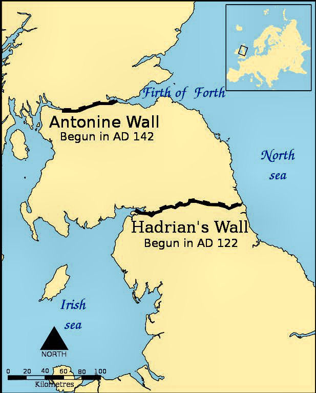
Created by Norman Einstein, derivative work: Talifero
CC BY-SA 3.0 Public domain
Getting back to the matter in hand, Hadrian’s Wall may not have been a primarily military defensive structure at all. In Roman times (700 - 930) the indigenous people and the Romans lived side by side both to the north of the wall just as they did to the south of it, working on their farms... or, maybe they weren't Romans at all.
This situation has also come to light on the Roman Empire’s eastern border in what is now Hungary...
Romans, “Huns and farmers ...borrowed ways of life from each other during the fifth century, [WS: 9th C] say archaeologist Susanne Hakenbeck of the University of Cambridge and colleagues. Nomadic Huns on the Roman frontier raised relatively small numbers of animals and grew some crops, while border-zone farmers incorporated more meat into what had been a wheat- and vegetable-heavy diet, the scientists report… ‘Our data show that the dietary strategies of the people on both sides of the Roman frontier were not fundamentally different,’ Hakenbeck says.” Source
Again, there’s a distinct lack of conflict in the archaeological evidence. Then again, this doesn't fit with Heinsohn's stratgraphic evidence that Imperial Rome was busy occupying Britain at this time. Furthermore…
“Still, geographic origins of the Huns are tough to pin down, says archaeologist Ursula Brosseder of the University of Bonn in Germany. The Huns developed as a political movement that picked up members from various ethnic groups as it spread, she explains. Brosseder suspects the ‘Hun phenomenon’ formed on the grasslands of Western Eurasia.” (ibid.)
Which is probably another line of research for another article… or maybe Part Two.
The idea that the Romans abandoned Britain in rather a hurry at some point during the period 409 – 418 is a product of the separation of history from archaeology. The same applies to the claims that the supply of coins to the western empire ceased not long before the same period and that the major British pottery manufacturers shut down in the early 400’s. If these events really did take place, they were the result of the 934 cataclysm, history has either edited them out of the 9th – 10th century or simply invented them and placed them into the 4th – 5th century.
What this also means is that the preconception regarding the invading Saxon hoards is also completely false. The indigenous British and whatever Germanic tribes there might have been, were all coexisting together at the same time:
“..Anglo-Saxon England was peopled with learned men and women, highly educated in Latin and English, who circulated and read Classical texts as well as composing their own… There survives a large corpus of literature showing a deep understanding of the physical and the metaphysical… Charters show that laws, administration and learning were not just for an educated elite. Laypeople were involved in the ceremonies and had documents created for them: land grants, wills,dispute settlements… The coinage across the period shows an elaborate and controlled economy. This was a well-managed society not given to lawlessness and chaos… They drew influence from Classical art and developed their own distinct artistic styles… They had trade routes stretching across the known world and were familiar with and able to buy spices, pigments and cloth from thousands of miles away (many manuscripts use a blue pigment made from lapis lazuli, brought from Afghanistan.” (‘Back to the Dark Ages’,Wiles K. 2016.)
This gives the impression of a highly civilised multiracial society existing in Britain during the period leading up to the cataclysm. Personally, I believe it to be an idealised and exaggerated impression that may have applied to a limited ‘elite’, if at all. There’s so much propaganda for the ‘multiracial’ agenda going on these days.
“...the widespread appearance of Germanic styles of dress, burial and building suggests that many natives adopted such things rapidly.” Source
The Saxon invasion was nothing like the historical narrative we have been force-fed. The Saxons are supposed to have arrived in southern England from Belgium and Holland at the same time as the Romans came from Gaul with their typical mafia-style protection racket approach. Gunnar Heinsohn claims that this took place during the stratigraphicy-based period of c. 670s-710s AD during the reign of Emperor Augustus. At this time, Aththe-Domaros of Camulodunum was the finest Celtic military leader in England and head of the Trinovantes, who were also said to be the most feared tribe in Britain. Their realm stretched from the north side of the Thames estuary (today’s Essex and Suffolk) to territory in London.
(Incidentally, the name ‘Trinovantes’ sounds eerily similar to Troia-novante or New Trojans. Geoffrey of Monmouth claimed that London was called Trinovantum or Trinovante at this time. But that’s all another rabbit-hole.)
Heinsohn believes that Aththe-Domaros was the factual basis for King Arthur, who’s epic failure to defeat the Saxons in later legend is based upon Aththe-Domaros’ defeat by the combined forces of the Romans and Saxons. However, that relies heavily upon there actually having been any invasion by Romans and/or Saxons. Both Felix and I have very different views about who or what King Arthur was as discussed in our article ‘A Quest for the Lost Realm of Faërie’. However, there seems no doubt that , if Aththe-Domaros really existed, then he was a ‘Man of Arthur’.
There are tales of how the Romans were fighting against the Saxons at the same time as they were invading Britain. Then there are also tales about how the Saxons were originally employed as mercenaries and that later they turned on their employers and took land in England for themselves. There’s also the claim that the Romans landed at Dover, but that wouldn’t have been possible as there was no sea in the Dover Strait until after the 10th century cataclysm. By the same token, there was no sea between the textbook invading Anglo-Saxons and England either...
Maybe the truth is something completely different. This is another subject we will revisit in future installments.
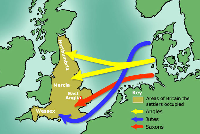
Textbook ‘Anglo-Saxon's invasion of Britian (sic) in 5th Century’
Source
"the Romans collected all the treasures that were in Britain, and some they hid in the earth, so that no one has since been able to find them; and some they carried with them into Gaul." (The Anglo-Saxon Chronicle)
Well, that has since been rectified because…
“Britain has yielded more caches of precious metal from AD 300–500 (700 – 900) than the rest of the Roman empire combined.” Source
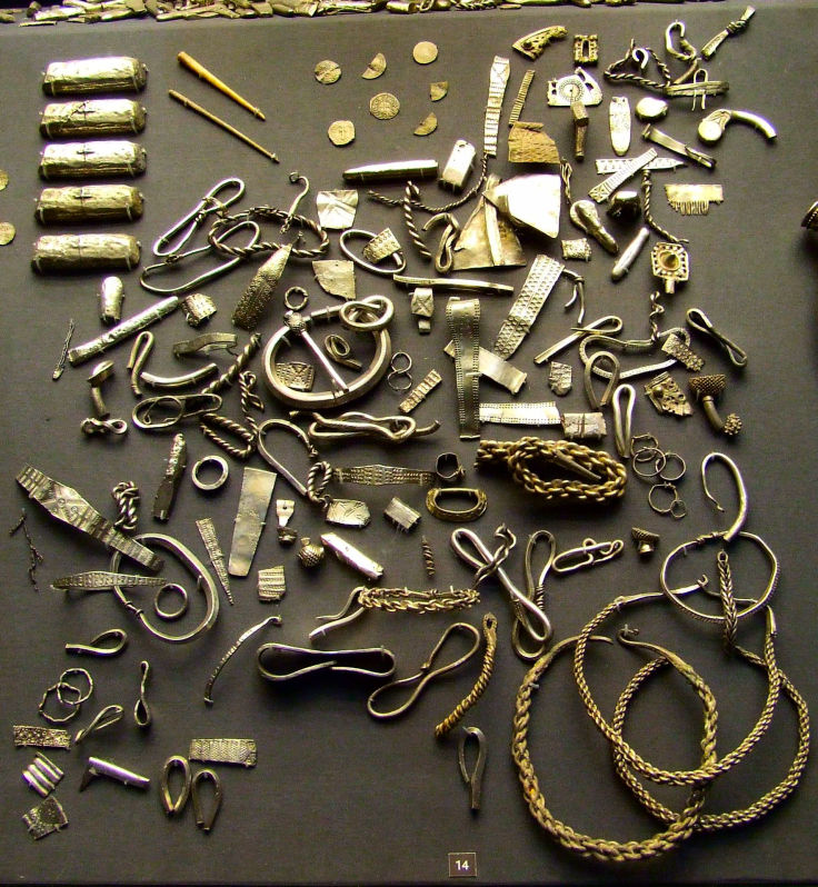
The Cuerdale Hoard. The largest hoard of ‘Viking' silver yet found in the UK. Comprised of more than 8,600 items. Discovered on the 15th May, 1840.
Source
The term ‘precious metal’ refers to “spectacular stockpiles of coins, plate and jewellery.” (ibid.) The thing is though, why? Were these people somehow forewarned of the impending cataclysm so that they buried what they couldn’t carry for retrieval at a later date, like pirates hiding their booty? Some was even buried inside lead tanks.
If these people were expecting Armageddon at the turn of the millennium, then it seems quite ridiculous that they would even entertain the idea of returning for their loot. Obviously, they thought there was a good chance of collecting their stash at some point in the future.
“Perhaps this anomaly was the product of particular concentrations of wealth in Roman Britain, or maybe there was some unknown factor preventing Britons from recovering their buried possessions as the Roman administration disintegrated.” Source
It always has to be Roman Britain. I suppose it's unthinkable that the indigenous British were capable of amassing any wealth by their own devices. Like there never having been any British people in York - only Romans and Vikings.
Again, according to the good old Anglo-Saxon Chronicle, the Romans took all the treasures they could carry to Gaul… which is a coincidence considering that’s the same area that the Norman… not Roman… Noroman, William the Bastard would invade Britain from 132 years later.
In his ‘The Betrayal of Albion’ article, Felix presented the case for the 1066 Norman Conquest being a fake event. He didn’t factor the cataclysm into his reasoning at that time. Now is his chance…
Thanks Will, the cataclysm does indeed make a great difference to the circumstances surrounding the Norman Conquest. The origins of the Normans as descendants of the Viking Rollo was invented by Dudo of Saint-Quentin in 1015 and is now taken as ‘gospel’. This and their absorption into the Frankish kingdom all began in 911, just 23 years before the cataclysm. The official narrative is full of supporting background information explaining why William the Bastard believed he was the rightful heir to the English throne. We hear of Anglo-Saxon kings and Danish kings who ruled England and the picture of a well established ancient Anglo-Saxon kingdom is well and truly painted. The so-called ‘Britons’ or ‘Celts’ are all supposed to have either been butchered or run away to Wales and Cornwall.
1066 was just 132 years after the cataclysm and yet we are supposed to believe that some itinerant Vikings established themselves as the Normans in northern France, went through all the shenanigans with the Anglo-Saxon kingdom of Britain (which never existed in the archaeological record) and got to a point where they could build about 696 ships and assemble an army of 10,000 men and 2,000 to 3,000 horses. It was “the largest amphibious operation in western Europe since the early days of the Roman Empire.”
Now there’s a thought… given that the vast majority of 1st millennium history is transplanted and/or duplicated, it’s very interesting to note that, coincidentally, Julius Caesar's 2nd invasion of Britain in 54 BC involved 628 ships, five legions and 2,000 cavalry. Caesar claimed descent from the Trojan Aenaeus, William claimed descent from Rollo, or ‘Roland’ in British English, which name Silveryou suggests could refer to one of the semi-mythical Paladins of Charlemagne.
If you combine this information with that presented in my ‘The Betrayal of Albion’ article it now looks even more unlikely that the Norman Conquest took place in anything like the manner presented by the official narrative, if at all.
However, the ‘mafiosi’ style rule of the Normans, who really were a diverse group of wealthy thugs sharing the common interest of greed and power, definitely would thrive in a post-cataclysmic setting. Calling it the ‘Feudal System’ doesn’t make it any more respectable.
The following situation also fits well within the scenario:
“Normandy’s wealth increased during the late tenth and early eleventh century, as a result of Viking plunder being sold at Norman ports, such as Rouen. In fact, it was even recorded in 1003 that Richard II signed a treaty with the Danish king, Sven Forkbeard, which allowed the Danes to use Norman ports – when attacking the English shoreline – in return for a share of the loot.” Source: ‘Early rebellion and its links to later success and conquest’, Matthew Paul Burke.
Many thanks again, Felix. So, if we accept the archaeological and geological evidence regarding the pre-cataclysmic geography of northern Europe and the British Isles, then the Roman conquest looks highly suspicious, unless they sailed across the narrower English Channel from Gaul. However, the textbook narrative claims that both Roman invasions landed at Deal or Dover which doesn’t work at all. So it seems that the Roman Invasion of Britain was a phantom duplication of the Norman Conquest, which itself was largely fiction. Therefore, both ‘conquests’ happened in an entirely different way to those we have been brainwashed with.
If the ‘elite’ merchant class (City of London) in Britain had somehow gained foresight of the impending cataclysm and either buried their wealth and / or took it with them to Gaul / France, then this band of rich refugees could well have become the Normans. Their re-infiltration of England after the cataclysm would probably have been achieved on a much smaller and slower piecemeal, terrorist-style basis:
“This writer has sought to show that it is possible that there was, in fact, an attempt to establish a number of Norman garrisons in England in the years 1051–1052;" Source: ‘A Pre-Conquest Norman Occupation of England,’ Speculum 46 (1971) 21–31.
Even in the official narrative there is much controversy over William’s legitimacy to the English throne, no doubt the creation and mirroring of the Roman Invasion story was a way of glorifying yet another defeat of the British and portraying William as a brave and valiant warrior, rather than the vicious inhuman thug he really was. Let’s not forget, he’s supposed to be the ancestor of all subsequent British monarchs.
To bring Part One to a close and to prevent me from rattling Part Two off here and now, I’d like to finish with a brief summing up.
We have successfully linked the Arctic Circle cataclysm with the Dark Earth cataclysm of the 10th century. The implications of this are significant in terms of gaining a better insight into the nature of the pre-cataclysmic world. Clearly the climate was able to support flora and fauna in the Arctic Circle that would not be able to survive today. The phenomena of the Northern Lights was vastly different in those times, like comparing an outdoor 3D Imax cinema with the Kinetoscope-type local display we have now. Our concept of extinct prehistoric mammals is also completely wrong – they were not prehistoric, just pre-official history.
We have seen confirmation of the climate situation from the various archaeological studies conducted in peat bogs, which show that the climate was able to support a practically year round growing season even in the north of Ireland. It has also been made evident that the academic blindness towards the archaeological evidence has resulted in completely false assumptions regarding human settlement, climate change, the development of human society, religious practices and the establishment of their factual basis, immigration and invasion across territories and basically who did what when and how. The land connection between England and northern Europe changes everything with regard to the racial and political history of the first millennium.
The artificial padding-out of the 7th – 10th centuries to make them encompass everything from about 60 BC onwards, has to have been a massive operation requiring substantial organisation and management. 700 years of ‘history’ is a lot to invent or duplicate or whatever methods they used. The best placed organisational structure to achieve this would, of course, be the religious one. It’s interesting to note that the artificially padded-out period correlates precisely to that which Christianity claims for its own establishment. The best placed power structure that could enforce adherence to the new religious dogma would be the ruling one.
The implications of the 10th century cataclysm and the redefinition of the events, chronology and geography of the first millennium will be discussed extensively in Part Two. It’s to be expected that the mutilation of history continued into the second millennium right up until today, as may people are well aware, therefore uncovering the originators of this deception is highly relevant to us right now. Obviously, much of this has to be speculation due to the almost total annihilation of any reliable sources, but that’s no reason not to make the attempt and, at worse, can only result in a different version of the fiction we call the official narrative.
The cause of the 10th century cataclysm is an enigma. I personally put more credence in the Fimbulwinter / Ragnarök scenario than in the comet / earthquake / tsunami ones, but that’s just my personal bias. However, there was certainly no shortage of supernatural, paranormal events leading up to, during and after the cataclysm. It wasn’t for nothing that the period had to be defined as ‘mythological’. We will be discussing this aspect in much more depth in forthcoming articles.
The Dark Earth Chronicles Part One
The Dark Earth Chronicles Part Two
The Dark Earth Chronicles Part 2.5
Editorial Update March 2024
The ‘History Revolution’ of the early 20th century
The Grail, The Cataclysm, The Wasteland and Our Lost Ancient Sovereignty
Updates and Re-Evaluation
Taliesin, The Divine Poisoner
Will Scarlet & Felix Noille
.
IF YOU ARE SEEING A LINK TO MOBIRISE, OR SOME NONSENSE ABOUT A FREE AI WEBSITE BUILDER, THEN IT IS A FRAUDULENT INSERTION BY THE PROVIDERS OF THE SUPPOSEDLY 'FREE' WEBSITE SOFTWARE USED TO CREATE THIS SITE. THEY ARE USING MY WEBHOSTING PLATFORM FOR THEIR OWN ADVERTISING PURPOSES WITHOUT MY CONSENT. TO REMOVE THESE LINKS I WOULD HAVE TO PAY A YEARLY FEE TO MOBIRISE ON TOP OF MY NORMAL WEBHOSTING EXPENSES - WHICH IS TANTAMOUNT TO BLACKMAIL. I CALCULATE THAT THEY CURRENTLY OWE ME THREE MILLION DOLLARS IN ADVERTISING REVENUE AND WEBSITE RENTAL.